Showing posts with label hurricane. Show all posts

Friday, September 30, 2016

Matthew Churning in the Caribbean, Much Uncertainty in Forecast


Matthew is now a Major Hurricane (meaning Category 3 or higher) located to the north of Venezuela and Colombia. In fact, there are Tropical Storm Warnings in effect for the northeastern coast of Colombia. Here is the latest information from the National Hurricane Center (11 AM EDT):


SUMMARY OF 1100 AM EDT...1500 UTC...INFORMATION
-----------------------------------------------
LOCATION...13.7N 70.8W
ABOUT 105 MI...170 KM NE OF PUNTA GALLINAS COLOMBIA
ABOUT 495 MI...800 KM SE OF KINGSTON JAMAICA
MAXIMUM SUSTAINED WINDS...115 MPH...185 KM/H
PRESENT MOVEMENT...WSW OR 255 DEGREES AT 12 MPH...19 KM/H
MINIMUM CENTRAL PRESSURE...968 MB...28.59 INCHES
Matthew is expected to continue west-southwestward for about the next 24 hours before making its northward turn. Now, where and when Matthew makes that northward turn has implications on where it will go after clearing Cuba. This is why the National Hurricane Center stated this:
It is important to remind users that average NHC track forecast
errors are around 175 miles at day 4 and 230 miles at day 5.
Therefore, it is too soon to rule out possible hurricane impacts
from Matthew in Florida.
It is important to note that the forecast cone is a projection of where the center of the system will go. Impacts can extend well outside the cone. Also, the cone is based on historical errors, and the center is predicted to be within the cone 67% of the time.

There is some concern for impacts on the United States. Generally, after 5 days, models lose skill in forecasting. However, with such high degree of uncertainty, there is decreased faith in the models. Here are the current spaghetti plots for Matthew:


In general, the models are in agreement of taking Matthew toward Jamaica and eastern Cuba and eventually into the Bahamas. However, the models have still been shifting east and west, and a shift in either direction has implications on later impacts.


This map shows the GFS Ensembles (GEFS). Basically, ensembles are just the same model (in this case, the GFS) run multiple times with slightly altered initial conditions. Thus, they help generate multiple different outcomes, giving us a probabilistic forecast. So, on this map, there is good agreement within the GFS ensembles that Matthew will move northward through the Bahamas to off the coast of the South Carolina. Afterward, there is much uncertainty. Now, let's look at the ECMWF Ensemble (EPS).


The ECMWF Ensembles are quite different. They are certain through about 48 hours continuing Matthew off to the west, then they become quite uncertain, ranging from the eastern Gulf of Mexico to well off the East Coast. Also notice the the EPS has a higher certainty in taking Matthew between Haiti and Cuba, whereas the GEFS had it over eastern Cuba.

So, what should you be doing? Well, if you're in Jamaica, eastern Cuba, or Haiti, you need be getting your plans and preparations done. It looks like those areas will be impacted in about 3 days. If you're in the Bahamas, start your preparations now as you are about 4 or 5 days out from impact. If you're along the East Coast of the U.S., you want to keep an eye on Matthew. Right now, it appears the main impacts will be increased swells and rip currents. Southeast Florida may have some gusty winds depending on how close Matthew gets to Florida.

Right now, it's still too early to give specifics on impacts to the U.S. or where Matthew will go after about 4 or 5 days out. So, the best advice is to keep watching if you're in the U.S., especially if you're along the East Coast.

Spaghetti Plots courtesy of TropicalTidbits.com
Ensemble plots courtesy of Dr. Brian Tang from the University of Albany: http://www.atmos.albany.edu/facstaff/tang/tcguidance/

Wednesday, September 28, 2016

18 Years Ago, A Storm Sparked My Interest in Weather


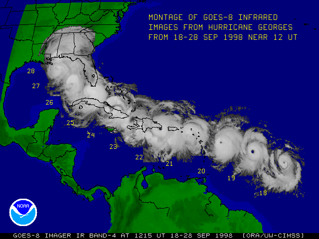
18 years ago on this day (September 28, 1998), Hurricane Georges roared ashore in southern Mississippi. 18 years and one day ago, my interest in weather was sparked. Below is my story from Hurricane Georges.

I had an interest in weather supposed since I was born. As my mom could attest, when I was 1 year old sitting in my playpen, my mom was watching the news. She figured that I didn't want to watch the news and turned it to cartoons. Apparently, I started bawling and crying. She then turned it back to the news, and I stopped. But, of course, I don't remember back that far, and thus, Hurricane Georges is my first moment that I realized I wanted to be a meteorologist.

I was 4 years old at the time. I was in my grandmother's bedroom while she was putting away some laundry, and my mom and her fiancee were in the living room watching TV. I had the Weather Channel on the TV in my grandmother's room watching the late John Hope give an update on Hurricane Georges. It was raining, it was windy. We were in the right front quadrant of Hurricane Georges, and we had a risk of tornadoes with the outer bands spiraling onshore. We were under a Tornado Watch. While I was in my grandmother's bedroom, my grandmother and I were oblivious to what was happening outside.

My mom was looking outside the kitchen window (which faces east). She saw what appeared to be lightning off in the distance. Her fiancee then looked out the window with her. The flashes started getting closer and there were loud pops going on. He then realized that those were transformers exploding.

The next thing we knew, our power went out, the house shook violently, and the wind was roaring outside. Immediately, somehow we all knew to get into our hallway bathroom (which is the most interior room without windows), even our dog knew. So we all crammed into the bathroom, closed the door, and my mom's fiancee started taking roll. We called out all our names except my grandmother. We were trying to figure out where she was. Then we hear a knock on the bathroom door, and there she is holding flashlights. Now, to her credit, she was from Vietnam and had no idea what was going on. All she thought about was that the power was out.

After being directly hit by a tornado, we looked outside from our window. We couldn't see a thing. Our entire neighborhood had no power. We called 911 and told them that we had been hit by a tornado, but they didn't believe us. They said that since there was no warning, there couldn't have been a tornado. They were partially right, there was no Tornado Warning issued. However, they sent one officer out our way. The Sheriff's Office was only a few blocks away, but they weren't impacted. However, the officer quickly had to call for back-up. They realized there was a substantial amount of damage. We could hear people yelling from the trailer park about 100 feet away to make sure everyone was okay. Unfortunately, we had to wait for daylight to see the full extent of the damage. One thing we knew, we didn't seem to have much damage. Everything still seemed in tact.

Daylight broke the next day (well, it was still cloudy as Georges was starting to make landfall in Mississippi), and we finally saw everything that had happened. Power lines and power poles down everywhere. Branches down. Even a tree in front of our house collapsed on the house across the street from us leaving a gaping hole in their roof. Thankfully, no one was home. But there was quite a bit of damage in our neighborhood. Every house around us had sustained some sort of damage (mostly in the form of roof damage. Our house had actually remained unscathed, just a few shingles off our roof, but no substantial damage. The tornado was rated an F1 (winds 73-112 mph), and it caused an estimated $300,000 in damage.

That got me interested in how the tornado seemingly skipped our house and the fact that there was actually no warning issued. I wanted to learn more about tornadoes, hurricanes, and pretty much everything. I also wanted to be the person to warn people about dangerous weather. I wanted to be on TV to be that person that people turn to when there's dangerous weather approaching. To this day, I carry this passion with me. I want to find ways to improve communication to the public through various media (television, online, social media). I want to give people a forecast they can understand while also teaching them something new. It's a dream that I can't wait to come true.

Friday, September 16, 2016

Hurricane Ivan: A Personal Recollection

September 16, 2004: Hurricane Ivan made landfall on the Fort Morgan Peninsula in southwestern Baldwin County, Alabama. Living near Fort Walton Beach, Florida, I was on the eastern side of the hurricane as it roared ashore. However, my family and I had evacuated to Jacksonville ahead of Ivan's rampage. This is my personal recount of Ivan.

The Evacuation to Jacksonville

As a 10-year-old weather enthusiast at the time (now, degreed meteorologist), I had been watching the tropics very closely. I had already seen Charley and Frances ravage the southern part of my state, and Ivan was showing a similar threat. Upon entering the Gulf of Mexico, Ivan was a formidable beast. There was still quite a bit of uncertainty, but we went under a Hurricane Watch on Monday night, while most of us were going to bed. Ivan was a powerful Category 5 Hurricane with winds of 160 mph. Here is the projected path and the advisory text from that time:


...EYE OF EXTREMELY DANGEROUS HURRICANE IVAN MOVING SLOWLY AWAY FROM
THE WESTERN TIP OF CUBA...HURRICANE WATCH ISSUED FOR NORTHERN GULF
COAST...
 
A HURRICANE WARNING REMAINS IN EFFECT FOR THE CUBAN PROVINCES OF
PINAR DEL RIO...HAVANA...CITY OF HAVANA...AND THE ISLE OF YOUTH.
 
A HURRICANE WARNING REMAINS IN EFFECT FOR THE NORTHEASTERN YUCATAN
PENINSULA FROM TULUM TO PROGRESO.
 
A TROPICAL STORM WATCH REMAINS IN EFFECT FOR THE FLORIDA KEYS FROM
THE SEVEN MILE BRIDGE WESTWARD...INCLUDING THE DRY TORTUGAS.
 
AT 11 PM EDT...0300Z...A HURRICANE WATCH HAS BEEN ISSUED FOR THE
NORTHERN GULF OF MEXICO COAST FROM EAST OF MORGAN CITY LOUISIANA
EASTWARD TO ST. MARKS FLORIDA...INCLUDING GREATER NEW ORLEANS
LOUISIANA.
 
AT 11 PM EDT...0300Z...THE EYE OF HURRICANE IVAN WAS LOCATED NEAR
LATITUDE 22.0 NORTH...LONGITUDE  85.4 WEST OR ABOUT 40 MILES...  60
KM...WEST-NORTHWEST OF THE WESTERN TIP OF CUBA.
 
IVAN IS MOVING TOWARD THE NORTHWEST NEAR  9 MPH...15 KM/HR...AND
THIS GENERAL MOTION IS EXPECTED TO CONTINUE FOR THE NEXT 24 HOURS.
 
MAXIMUM SUSTAINED WINDS ARE NEAR 160 MPH...260 KM/HR...WITH HIGHER
GUSTS.  IVAN IS AN EXTREMELY DANGEROUS CATEGORY 5 HURRICANE ON THE
SAFFIR-SIMPSON HURRICANE SCALE.  NO SIGNIFICANT CHANGE IN STRENGTH
IS FORECAST DURING THE NEXT 24 HOURS.
 
HURRICANE FORCE WINDS EXTEND OUTWARD UP TO 100 MILES...160 KM...
FROM THE CENTER...AND TROPICAL STORM FORCE WINDS EXTEND OUTWARD UP
TO 200 MILES...325 KM.
 
THE MINIMUM CENTRAL PRESSURE REPORTED BY HURRICANE HUNTER AIRCRAFT
WAS  914 MB...26.99 INCHES.
At this time, Ivan was forecast to make landfall as a 140-mph Category 4 Hurricane somewhere between Morgan City, LA, and St. Marks, FL. When we woke up the next morning, we were waiting to hear about evacuations. The last hurricane to hit the Florida Panhandle was Hurricane Opal, the benchmark storm for Northwest Florida. My mom's then-fiancee was stationed at Hurlburt Field, and the military has different evacuation procedures, and he was told to evacuate, so my mom, my grandmother, myself, and our two dogs packed up our bags and started our evacuation process. Unfortunately, when you live in a military community where most of the population is military, everyone still evacuated at the same time. Plus, Okaloosa County (and several other counties) were starting their evacuation processes. So, our original destination was Lake City (near the I-10/I-75 junction). For those that aren't familiar with Okaloosa County, there are only two ways to get to the interstate for those of us in the coastal regions: State Road 85 and State Road 285. State Road 85 is a 4-lane highway between Shalimar and Crestview. State Road 285 is a 2-lane highway between Niceville and Mossy Head. Those are the only 2 ways to Interstate 10 for Okaloosa County residents. Why are there only 2 ways out of coastal Okaloosa County? Eglin Air Force Base takes up the entire central portion of the county, and there are numerous test sites scattered across the county. Also, several missions that are conducted are light-sensitive, so the military can't have too much light pollution from highways.


So, we begin our evacuation process. What normally is a 20-30 minute drive to Crestview was a 4-hour drive. So, if you do the math: 22.6 miles in 4 hours, that's roughly 5-6 mph average speed. I believe we left around 11 AM that morning. We had our car stocked up with gas and snacks for us and our dogs. My grandpa stayed behind. He worked as the dock supervisor for a local newspaper, and he had to stay behind for work. We got to the interstate around 3 PM that afternoon. By that time, we wanted to get out of the car, stretch our legs, use the restroom, and let our dogs use the restroom. There is a rest stop just to the east of Crestview (about 2 or 3 miles to the east). When we finally approached the rest stop, much to our disappointment and frustration (along with many other people), the rest stop was closed. Since the interstate was in total gridlock, we, along with several other people, pulled onto the shoulder or median of the interstate to do what we needed to. So, we were on our way to Lake City, very slowly.


Again, what normally takes about 3.5 hours took us about 6 or 7 hours. Rest areas were closed all the way through Marianna ahead of Hurricane Ivan. We got a hotel in Lake City and turned on to see the latest information on Hurricane Ivan. This is the advisory that we saw:


...LARGE AND EXTREMELY DANGEROUS HURRICANE IVAN HEADED FOR THE
NORTHERN GULF COAST...

A HURRICANE WARNING IS IN EFFECT FROM GRAND ISLE LOUISIANA TO
APALACHICOLA FLORIDA...INCLUDING THE GREATER NEW ORLEANS AREA AND
LAKE PONTCHARTRAIN.  A HURRICANE WARNING MEANS THAT HURRICANE
CONDITIONS ARE EXPECTED WITHIN THE WARNING AREA...GENERALLY WITHIN
THE NEXT 24 HOURS.  PREPARATIONS TO PROTECT LIFE AND PROPERTY
SHOULD BE RUSHED TO COMPLETION THROUGHOUT THE ENTIRE WARNING AREA.
 
A HURRICANE WATCH REMAINS IN EFFECT FROM MORGAN CITY LOUISIANA TO
WEST OF GRAND ISLE.
 
A TROPICAL STORM WARNING IS IN EFFECT FROM INTRACOASTAL CITY
LOUISIANA TO WEST OF GRAND ISLE...AND FROM EAST OF APALACHICOLA TO
YANKEETOWN FLORIDA.  A TROPICAL STORM WARNING MEANS THAT TROPICAL
STORM CONDITIONS ARE EXPECTED WITHIN THE WARNING AREA WITHIN THE
NEXT 24 HOURS.
 
AT 10 PM CDT...0300Z...THE TROPICAL STORM WATCH FOR THE FLORIDA KEYS
FROM THE SEVEN MILE BRIDGE WESTWARD...INCLUDING THE DRY TORTUGAS...
HAS BEEN DISCONTINUED.

AT 10 PM CDT...0300Z...THE EYE OF HURRICANE IVAN WAS LOCATED NEAR
LATITUDE 25.1 NORTH... LONGITUDE 87.2 WEST OR ABOUT 295 MILES
SOUTH-SOUTHEAST OF THE MOUTH OF THE MISSISSIPPI RIVER.

IVAN IS MOVING TOWARD THE NORTH-NORTHWEST NEAR 12 MPH AND A GRADUAL
TURN TO THE NORTH IS EXPECTED ON WEDNESDAY.
 
MAXIMUM SUSTAINED WINDS ARE NEAR 140 MPH...WITH HIGHER GUSTS. IVAN
REMAINS AN EXTREMELY DANGEROUS CATEGORY FOUR HURRICANE ON THE
SAFFIR-SIMPSON HURRICANE SCALE. FLUCTUATIONS IN INTENSITY ARE
COMMON IN MAJOR HURRICANES AND ARE POSSIBLE OVER THE NEXT 24 HOURS.
IVAN IS EXPECTED TO MAKE LANDFALL AS A MAJOR HURRICANE...AT LEAST
CATEGORY THREE.

IVAN IS A LARGE HURRICANE.  HURRICANE FORCE WINDS EXTEND OUTWARD UP
TO 105 MILES FROM THE CENTER...AND TROPICAL STORM FORCE WINDS
EXTEND OUTWARD UP TO 260 MILES.  HURRICANE FORCE WINDS ARE EXPECTED
TO SPREAD INLAND UP TO ABOUT 150 MILES NEAR THE PATH OF IVAN.

A NOAA HURRICANE HUNTER AIRCRAFT MEASURED A MINIMUM CENTRAL PRESSURE
OF 932 MB...27.52 INCHES.
As any evacuee will tell you, the thought of not having a home to come back to is the most nerve-wracking thing ever. The local forecast in Lake City called for the possibility of rain bands and isolated tornadoes. So, we decided to try going further east, to Jacksonville. We called to check in on my grandpa, and he was fine, saying that he was going to stay at work through the hurricane.

The next morning, we got back on the road to Jacksonville and got to a hotel without much trouble. We settled in our hotel room and turned on the news to see the latest information:


...LARGE AND DANGEROUS HURRICANE IVAN MOVING NORTHWARD TOWARD THE
GULF COAST...

A HURRICANE WARNING IS IN EFFECT FROM GRAND ISLE LOUISIANA TO
APALACHICOLA FLORIDA...INCLUDING THE GREATER NEW ORLEANS AREA AND
LAKE PONTCHARTRAIN.  A HURRICANE WARNING MEANS THAT HURRICANE
CONDITIONS ARE EXPECTED WITHIN THE WARNING AREA...GENERALLY WITHIN
THE NEXT 24 HOURS.  PREPARATIONS TO PROTECT LIFE AND PROPERTY
SHOULD BE RUSHED TO COMPLETION THROUGHOUT THE ENTIRE WARNING AREA.
 
A HURRICANE WATCH REMAINS IN EFFECT FROM MORGAN CITY LOUISIANA TO
WEST OF GRAND ISLE.
 
A TROPICAL STORM WARNING IS IN EFFECT FROM INTRACOASTAL CITY
LOUISIANA TO WEST OF GRAND ISLE...AND FROM EAST OF APALACHICOLA TO
YANKEETOWN FLORIDA.  A TROPICAL STORM WARNING MEANS THAT TROPICAL
STORM CONDITIONS ARE EXPECTED WITHIN THE WARNING AREA WITHIN THE
NEXT 24 HOURS.
 
AT 10 AM CDT...1500Z...THE CENTER OF HURRICANE IVAN WAS LOCATED NEAR
LATITUDE 27.3 NORTH...LONGITUDE 88.0 WEST OR ABOUT 235 MILES SOUTH
OF MOBILE ALABAMA.
 
IVAN IS MOVING TOWARD THE NORTH NEAR 13 MPH...AND THIS MOTION IS
EXPECTED TO CONTINUE OVER THE NEXT 24 HOURS.  ON THE FORECAST
TRACK...THE CENTER OF IVAN IS EXPECTED TO REACH THE COAST DURING
THE VERY EARLY MORNING HOURS ON THURSDAY.
 
IVAN CONTINUES AS AS A EXTREMELY DANGEROUS CATEGORY FOUR HURRICANE
ON THE SAFFIR/SIMPSON SCALE HURRICANE SCALE...WITH MAXIMUM SUSTAINED
WINDS NEAR 135 MPH...WITH HIGHER GUSTS.  SOME FLUCTUATIONS IN
INTENSITY ARE EXPECTED DURING THE NEXT 24 HOURS...BUT IVAN IS
EXPECTED TO MAKE LANDFALL AS A MAJOR HURRICANE...CATEGORY
THREE OR HIGHER.  OCCUPANTS OF HIGH-RISE BUILDINGS WITHIN THE
HURRICANE WARNING AREA CAN EXPECT HIGHER WINDS THAN THOSE
EXPERIENCED AT THE SURFACE...ABOUT ONE SAFFIR-SIMPSON CATEGORY
HIGHER AT THE TOP OF A 30-STORY BUILDING.  AFTER LANDFALL...
HURRICANE FORCE WINDS COULD TO SPREAD INLAND UP TO 100 MILES NEAR
THE PATH OF THE CENTER.  

IVAN IS A LARGE HURRICANE...WITH HURRICANE FORCE WINDS EXTENDING
OUTWARD UP TO 105 MILES FROM THE CENTER...AND TROPICAL STORM FORCE
WINDS EXTENDING OUTWARD UP TO 290 MILES.
 
ESTIMATED MINIMUM CENTRAL PRESSURE IS  939 MB...27.73 INCHES.

Ivan Makes Landfall

We knew it was going to be bad. This was rivaling Hurricane Opal back in 1995. But, we decided to try to get our mind off of things. We went down to Atlantic Beach and did some shell-collecting. It was my first time ever seeing the Atlantic Ocean, so that was cool. Though, to be honest, I was disappointed with the beaches. I had been spoiled by the soft, white sands that the Panhandle had to offer. The hard, brown sand was quite disgusting to me. We got back to the hotel and freshened up before dinner. We walked to the restaurant that was next door to our hotel. Within that short time, a car drove by, and the people inside through coins at us as we walked. One of the coins hit my mom in the shoulder, leaving a sizable bruise. That left a horrible impression of Jacksonville for us. We came back to the hotel and saw Ivan was nearing landfall. We contacted my grandpa again to see how he was holding up, and he was doing okay. They had their supplies at his workplace and still had power. We went to bed that night hoping and praying we had a place to come back to.
...EXTREMELY DANGEROUS HURRICANE IVAN ABOUT TO CROSS THE ALABAMA
COASTLINE...
 
A HURRICANE WARNING IS IN EFFECT FROM GRAND ISLE LOUISIANA TO
APALACHICOLA FLORIDA...INCLUDING THE GREATER NEW ORLEANS AREA AND
LAKE PONTCHARTRAIN.  A HURRICANE WARNING MEANS THAT HURRICANE
CONDITIONS ARE EXPECTED WITHIN THE WARNING AREA...GENERALLY WITHIN
THE NEXT 24 HOURS.  PREPARATIONS TO PROTECT LIFE AND PROPERTY
SHOULD BE RUSHED TO COMPLETION THROUGHOUT THE ENTIRE WARNING AREA.
 
A HURRICANE WATCH REMAINS IN EFFECT FROM MORGAN CITY LOUISIANA TO
WEST OF GRAND ISLE.
 
A TROPICAL STORM WARNING REMAINS IN EFFECT FROM MORGAN CITY TO WEST
OF GRAND ISLE...AND FROM EAST OF APALACHICOLA TO YANKEETOWN
FLORIDA.
 
AT 2 AM CDT...0700Z...THE LARGE EYE OF HURRICANE IVAN WAS CENTERED
NEAR LATITUDE 30.2 NORTH...LONGITUDE 87.8 WEST...VERY NEAR THE
ALABAMA COASTLINE.
 
IVAN IS MOVING SLIGHTLY EAST OF DUE NORTH NEAR 13 MPH...AND THIS
MOTION IS EXPECTED TO CONTINUE FOR THE NEXT 24 HOURS.  ON THE
FORECAST TRACK...THE CORE OF THE HURRICANE WILL BE ON THE COAST
SHORTLY.
 
MAXIMUM SUSTAINED WINDS HAVE DECREASED TO NEAR 130 MPH...WITH HIGHER
GUSTS. A GRADUAL WEAKENING SHOULD CONTINUE AS THE HURRICANE MOVES
INLAND. OCCUPANTS OF HIGH-RISE BUILDINGS WITHIN THE HURRICANE
WARNING AREA CAN EXPECT HIGHER WINDS THAN THOSE EXPERIENCED AT THE
SURFACE...ABOUT ONE SAFFIR-SIMPSON CATEGORY HIGHER AT THE TOP OF A
30-STORY BUILDING.  HURRICANE FORCE WINDS COULD SPREAD INLAND UP TO
ABOUT 150 MILES NEAR THE PATH OF THE CENTER.
 
PEOPLE ARE STRONGLY ADVISED NOT TO VENTURE OUT FROM SHELTER DURING
THE CALM CONDITIONS OF THE EYE...AS WINDS WILL INCREASE RAPIDLY
WITH LITTLE OR NO WARNING WHEN THE EYE PASSES.
 
HURRICANE FORCE WINDS EXTEND OUTWARD UP TO 105 MILES FROM THE
CENTER...AND TROPICAL STORM FORCE WINDS EXTEND OUTWARD UP
TO 290 MILES.  THE PENSACOLA NAVAL AIR STATION RECENTLY REPORTED A
WIND GUST TO 98 MPH.
 
THE LATEST MINIMUM CENTRAL PRESSURE MEASURED BY A NOAA HURRICANE
HUNTER AIRCRAFT WAS  943 MB...27.85 INCHES.
The next morning, the news coming back was mostly from Pensacola. There was substantial damage in Pensacola, but we hadn't heard anything coming from Okaloosa County. We couldn't get in touch with my grandpa, because cellular service was heavily interrupted. We waited through the day to get in contact with him. Later that night, we heard back from him. He said that our house was okay, but most of shingles were blown off the roof and several branches and limbs were all over the yard.

The Journey Back Home

We heard that it was safe for us to return to Okaloosa County, so we packed up our stuff and started heading back. As we headed back west on Interstate 10, we didn't see much damage, maybe some trees down as we got closer to Northwest Florida. We were near Chipley when we heard on the radio that part of the I-10 overpass over US Highway 331 had collapsed. So, we got to Ponce de Leon and got off of I-10 and headed down to State Road 20, which runs along the northern shore of Choctawhatchee Bay. We couldn't get on US Highway 98, because it was washed out between Destin and Fort Walton Beach. Being closer to the coast, we saw more damage to trees and some homes. We ventured westward on State Road 20. As we approached Choctaw Beach, part of State Road 20 (a 2 lane highway) had collapsed into the bay. Out there, there are no detours. We were in a long line of cars trying to make our way back home. So we did what we had to do, we started driving in people's yards alongside State Road 20. We eventually got away from the bay as the highway bent a bit further north. Coming into Bluewater Bay and Niceville, power poles were down everywhere. There was no power whatsoever. We came into Shalimar, back home, and there were traffic lights scattered everywhere across the highway, trees down, and power lines everywhere. Thankfully my house and others' houses in my neighborhood were not significantly damaged.

The Aftermath

I wish I could say that everything was easy for us after the hurricane since we didn't have damage. Well, of course, without power, there is no gas, no stores were open, and if any of them were open, there was no food. Water was shut off. Really, there wasn't much we could do. My mom and I drove around town and looked at the damage. Power poles and trees toppled, boats on Highway 98 in downtown Fort Walton Beach, buildings damaged. From my mom's perspective, it looked eerily similar to damage from Opal. No one was allowed onto Okaloosa Island. One, Highway 98 was washed away. Two, there was significant damage along the island. Over the coming days, the local military bases started dispersing MREs (meals-ready-to-eat) to all local residents. I personally liked them, but of course, you really want real food. Power started getting restored slowly. We were without power for about 2 weeks after the hurricane (and 2 weeks without air conditioning in late September is horrible). We got a tarp to put over our roof until it got repaired. Stores were starting to get supplies in. Schools were starting back up. We were starting to get back to a sense of normalcy. Everything was going to be okay.

But That's Not All...

We had our power on for about 5 days or so. I was on my way back from school with my mom, and we turned into our neighborhood and saw state troopers and firefighters blocking off the road ahead. Turns out, they were blocking off our street and surrounding our house. We parked about a block away and walked closer, and the state troopers stopped us. They asked if we lived in the house that they were surrounding, and we answered, "Yes." We got a quick look at what had happened. There was more damage to our yard. We asked what had happened.

Apparently, a dump truck carrying broken limbs and trees had snagged a power line (which was marked with flags because it was low-hanging) and dragged the power pole next to our yard down into our yard. The pole had crushed my grandpa's truck, totaling it. The transformer on the pole exploded in our yard, leaking oil all over our driveway and our yard.  The Hazmat crew had already cleaned everything up. There were no witnesses to the incident, so we couldn't track down who owned the truck. The wires attaching our house to the power grid were ripped from our house, and we were without power yet again. About 2 or 3 days later, the power company repaired the pole, transformer, and power lines, but we were still without power. We called several electricians to come repair our wires to get reconnected to the power grid, and there was a whole bunch of arguing of whose responsibility it was (was it the power company's or the electrician's to fix those wires). After about 2 weeks of back-and-forth, we finally got power back permanently in mid-October, about 4 weeks after Ivan had struck. Thankfully, it was done for now.

But little did we know, that we'd have to evacuate again about 10 months later...


By the way, if you want a more meteorological approach to Ivan and its impacts to southern Alabama and northwest Florida, the National Weather Service office in Mobile has a great write-up here.

Tuesday, September 13, 2016

Active Tropics: Ian and Julia in the Atlantic, Orlene in the Eastern Pacific, Meranti near Taiwan

Two tropical storms in the Atlantic, a hurricane in the eastern Pacific, and a super typhoon and tropical storm in the western Pacific - pretty much describes September in the tropics. Let's start in the western Pacific with Meranti.

SUPER TYPHOON MERANTI


This is Super Typhoon Meranti. It has just passed by (as of 9 PM CDT/02Z) the southern tip of Taiwan. It is starting to weaken as the eye of Meranti is starting to become covered in clouds and is cooling (brighter colors). Generally, for a healthy tropical cyclone, you want cold-topped thunderstorms with a warmer eye. The greater the contrast between the thunderstorms near the center and the eye, the stronger the tropical cyclone is. Also, interesting fact: earlier today, Meranti became tied for 2nd for the strongest winds estimated for a typhoon in the western Pacific with winds of 190 mph. The strongest winds estimated for a typhoon were 195 mph from Super Typhoon Haiyan in 2013. Satellite estimation is most common with systems that are over open waters and away from any observation sites. The most common satellite estimation techinique is the Dvorak method. You can read more about it here. The strongest winds ever recorded for a tropical cyclone, period, was Hurricane Patricia with sustained winds of 215 mph! Here is the latest (7 PM CDT/00Z) advisory information from the Joint Typhoon Warning Center:


Meranti was located at 21.6 N, 120.7 E, moving NW at 15 mph. The maximum sustained winds (estimated by satellite) were 180 mph, making Meranti a Super Typhoon and equivalent to a Category 5 Hurricane on the Saffir-Simpson Hurricane Wind Scale. Meranti is forecast to continue moving northwestward toward mainland China, possibly landfalling as a typhoon. Heavy rain will lead to flooding across portions of southeast China over the coming days.

TROPICAL STORM MALAKAS


This is Tropical Storm Malakas in the western Pacific east of the Philippines. Malakas is not expected to directly impact the Philippines, but could pose a threat to Japan over the coming days. Here is the latest (7 PM CDT/00Z) advisory information for Malakas from the Joint Typhoon Warning Center:


Malakas is currently located at 15.5 N, 133.0 E, and is moving WNW at 18 mph. Maximum sustained winds (estimated) are near 70 mph. Malakas is expected to intensify and gain typhoon status shortly and continue strengthening as it moves primarily to the north of Taiwan, though it is not currently forecast to become a super typhoon. However, Malakas is currently forecast to impact southern Japan as a typhoon in the coming days.

HURRICANE ORLENE


This is Hurricane Orlene in the eastern Pacific. Orlene is just drifting around right now, but is expected to make a turn toward the west soon. Here is the latest (10 PM CDT/03Z) information for Orlene from the National Hurricane Center:

SUMMARY OF 800 PM PDT...0300 UTC...INFORMATION
----------------------------------------------
LOCATION...20.4N 118.6W
ABOUT 585 MI...940 KM WSW OF THE SOUTHERN TIP OF BAJA CALIFORNIA
MAXIMUM SUSTAINED WINDS...85 MPH...140 KM/H
PRESENT MOVEMENT...N OR 360 DEGREES AT 1 MPH...2 KM/H
MINIMUM CENTRAL PRESSURE...980 MB...28.94 INCHES
Yes, you read that correctly. Orlene is moving north at 1 mph. That's probably the slowest setting you have on your treadmill. Orlene is expected to weaken as it makes its westward turn, and could weaken back to tropical depression status this weekend.

TROPICAL STORM IAN


Ian is still rather disorganized. If you look closely, you can see that the center is south of the main area of convection as Ian continues to deal with strong southerly shear. This has helped to inhibit any major strengthening thus far. Here is the latest (10 PM CDT/03Z) information from Ian from the National Hurricane Center:


SUMMARY OF 1100 PM AST...0300 UTC...INFORMATION
-----------------------------------------------
LOCATION...27.6N 52.8W
ABOUT 785 MI...1265 KM ESE OF BERMUDA
MAXIMUM SUSTAINED WINDS...50 MPH...85 KM/H
PRESENT MOVEMENT...NNW OR 345 DEGREES AT 13 MPH...20 KM/H
MINIMUM CENTRAL PRESSURE...998 MB...29.47 INCHES
Ian is expected to remain away from any land areas and affect no one. That's what we like to see. Ian may strengthen a bit more, and some guidance brings it close to hurricane status. The official forecast calls for a maximum intensity of 65 mph.

TROPICAL STORM JULIA


Surprise! Well, sort of. This was Invest 93-L. The National Hurricane Center at 7 AM CDT Tuesday morning gave this a "near 0% chance" of formation, because it was rather disorganized. Then, at 1 PM CDT, the National Hurricane Center upped the chances to 40%, noting that organization was increasing and that advisories could be initiated soon. They decided not to initiate advisories at 4 PM CDT, but increased the chances of development to 70% at 7 PM CDT. At 10 PM CDT, the National Hurricane Center officially declared this a tropical storm. But, there's something weird about Julia's formation. Technically, Julia became a tropical storm over land. While it has happened before, it is a very rare occurrence. What may have happened is that as 93L paralleled the coast of northeastern Florida, the friction from the land versus the water helped tighten up the circulation moreso, giving 93L more organization. Tropical storm force winds are possible in some of the rainbands. So, here is the latest (10 PM CDT/03Z) information from the National Hurricane Center:

SUMMARY OF 1100 PM EDT...0300 UTC...INFORMATION
-----------------------------------------------
LOCATION...30.3N 81.6W
ABOUT 5 MI...10 KM W OF JACKSONVILLE FLORIDA
ABOUT 60 MI...100 KM S OF BRUNSWICK GEORGIA
MAXIMUM SUSTAINED WINDS...40 MPH...65 KM/H
PRESENT MOVEMENT...NNW OR 345 DEGREES AT 9 MPH...15 KM/H
MINIMUM CENTRAL PRESSURE...1009 MB...29.80 INCHES
There are Tropical Storm Warnings in effect for some locations:

  • In Florida: coastal Nassau and coastal Duval counties
  • In Georgia: Glynn and Camden counties
Julia is expected to move further northward into southern Georgia and weaken. The main threat from Julia will be very heavy rainfall across northeast Florida, southeast Georgia, and parts of coastal South Carolina. 3-6 inches of rain is possible with localized amounts near 10 inches. Also, can't rule out an isolated tornado. In fact, there was a confirmed tornado near Barefoot Bay in Brevard County, Florida Tuesday afternoon.

INVEST 95L


Our final stop takes us out to the other side of the Atlantic near the Cabo Verde Islands. This is Invest 95L, It is moving off to the west-northwest, bring heavy rain and gusty winds to the Cabo Verde Islands. Here is the latest (7 PM CDT/00Z) from the National Hurricane Center:

A broad area of low pressure, associated with a tropical wave,
located a couple of hundred miles east-southeast of the Cabo Verde
Islands is producing a large area of disorganized cloudiness and
showers.  Slow development of this disturbance is possible during
the next several days while it moves west-northwestward at 10 to 15
mph over the tropical Atlantic.  Regardless of development, locally
heavy rains and gusty winds are likely over portions of the Cabo
Verde Islands through Wednesday.
* Formation chance through 48 hours...medium...40 percent
* Formation chance through 5 days...medium...60 percent
Some development from 95L is possible over the coming days. Here are the latest model runs for 95L:


Once 95L clears the Cabo Verde Islands, it will continue on a west or west-northwest track over the open tropical Atlantic, not affecting any land in the forseeable future. But, if 95L does become a named storm, the next name on the list is Karl.

Monday, September 12, 2016

Taiwan's Tropical Threat, Ian Forms in the Atlantic

It's September, and we expect the tropics to be active this time of year. We are in the peak of Hurricane Season in the Atlantic, and we do have some activity to watch. But, we start (as our title suggests) in the western Pacific.

SUPER TYPHOON MERANTI


Now, since we are in the western north Pacific (north of the Equator, west of the International Date Line), hurricanes are known as "typhoons." "Super typhoons" are typhoons with winds of 150 mph or greater (equivalent to an upper end Category 4 or Category 5 hurricane). Here is the latest advisory information from the Joint Typhoon Warning Center:


As of 7 AM CDT (12Z) this morning, STY Meranti was located near 18.9N, 128.2E. Meranti was moving WNW at 14 mph. Maximum sustained winds were at 180 mph (equivalent to a powerful Category 5 hurricane). Meranti is expected to move WNW toward southern Taiwan and potentially make landfall as a Super Typhoon with winds of 155 mph. Very heavy rain (especially with mountain influence) and potentially catastrophic winds are possible as Meranti moves very near or over Taiwan. Meranti is then expected to continue moving into mainland China.

HURRICANE ORLENE


This is Hurricane Orlene in the eastern Pacific. Right now, Orlene is well away from land and isn't expected to impact land over the next several days. Here is the latest advisory information from the National Hurricane Center:


SUMMARY OF 800 AM PDT...1500 UTC...INFORMATION
----------------------------------------------
LOCATION...17.4N 119.3W
ABOUT 720 MI...1155 KM WSW OF THE SOUTHERN TIP OF BAJA CALIFORNIA
MAXIMUM SUSTAINED WINDS...90 MPH...150 KM/H
PRESENT MOVEMENT...NW OR 320 DEGREES AT 6 MPH...9 KM/H
MINIMUM CENTRAL PRESSURE...980 MB...28.94 INCHES
Orlene will continue drifting northward through Tuesday before making a turn back to the west by Wednesday, and also will slowly weaken back to tropical storm status.

TROPICAL STORM IAN


Advisories were initiated on Tropical Storm Ian at 10 AM CDT Monday morning. On satellite, you see the center is exposed on the southwestern side of the convection. This is because Ian is on the west side of an upper-level trough, and is being sheared. Here is the latest advisory information from the National Hurricane Center:


SUMMARY OF 1100 AM AST...1500 UTC...INFORMATION
-----------------------------------------------
LOCATION...21.8N 50.4W
ABOUT 1140 MI...1840 KM SE OF BERMUDA
MAXIMUM SUSTAINED WINDS...40 MPH...65 KM/H
PRESENT MOVEMENT...NW OR 320 DEGREES AT 13 MPH...20 KM/H
MINIMUM CENTRAL PRESSURE...1007 MB...29.74 INCHES
Right now, Ian is not expected to become a hurricane, but it could get close. Thankfully, Ian looks to remain away from land throughout its lifetime.

INVEST 93L


Now, the path of 93L looks somewhat ominous, taking it over the Florida Peninsula, but I can assure you it's not as bad as it looks. 93L looks very ragged:


There is no sign of a closed surface circulation. Plus, the showers and thunderstorms are very disorganized. The National Hurricane Center gives 93L only a 10% chance of developing over the next 5 days. The main impact will be heavy rain over the Bahamas and parts of Florida. Increased moisture will lead to higher rain chances across portions of the Southeast as well.

Remember to always be prepared as we continue through Hurricane Season.

Wednesday, August 31, 2016

Tropical Threats to Hawaii and Florida

There are not one, not two, but THREE tropical cyclones that are threatening the United States, namely Hawaii and Florida. First, here is a quick update on the other systems.

HURRICANE GASTON


Gaston is a Category 2 hurricane tracking east-northeastward across the northern Atlantic. Gaston could affect the Azores into this weekend as a weakening tropical storm. Here is the latest track and information from the National Hurricane Center:


SUMMARY OF 1100 PM AST...0300 UTC...INFORMATION
-----------------------------------------------
LOCATION...36.0N 45.4W
ABOUT 935 MI...1500 KM W OF FAIAL ISLAND IN THE CENTRAL AZORES
ABOUT 1020 MI...1640 KM W OF LAJES AIR BASE IN THE AZORES
MAXIMUM SUSTAINED WINDS...105 MPH...165 KM/H
PRESENT MOVEMENT...NE OR 55 DEGREES AT 20 MPH...31 KM/H
MINIMUM CENTRAL PRESSURE...970 MB...28.65 INCHES
A Tropical Storm Watch has been issued for a part of the Azores. A TROPICAL STORM WATCH means that tropical storm conditions (winds of 39-74 mph) are possible within the next 48 hours.

TROPICAL DEPRESSION EIGHT


Tropical Depression Eight is moving away from the North Carolina Outer Banks. Minimal impacts expected. Just some higher waves and dangerous rip currents expected. TD 8 is expected to merge with a front as it accelerates northeastward. Here is the latest from the National Hurricane Center:

SUMMARY OF 1100 PM EDT...0300 UTC...INFORMATION
-----------------------------------------------
LOCATION...36.7N 70.1W
ABOUT 320 MI...515 KM ENE OF CAPE HATTERAS NORTH CAROLINA
ABOUT 1110 MI...1790 KM WSW OF CAPE RACE NEWFOUNDLAND
MAXIMUM SUSTAINED WINDS...30 MPH...45 KM/H
PRESENT MOVEMENT...ENE OR 65 DEGREES AT 18 MPH...30 KM/H
MINIMUM CENTRAL PRESSURE...1010 MB...29.83 INCHES
Now, lets start talking about the threats to Hawaii.

TROPICAL STORM MADELINE


Madeline has weakened from a major hurricane yesterday back to a tropical storm now. However, Hawai'i as a whole is not accustomed to hurricanes or strong tropical storms. So this is a serious threat. Here is the latest information and track for Hurricane Madeline from the Central Pacific Hurricane Center:


SUMMARY OF 500 PM HST...0300 UTC...INFORMATION
----------------------------------------------
LOCATION...18.0N 155.1W
ABOUT 115 MI...190 KM S OF HILO HAWAII
ABOUT 290 MI...470 KM SE OF HONOLULU HAWAII
MAXIMUM SUSTAINED WINDS...65 MPH...100 KM/H
PRESENT MOVEMENT...WSW OR 250 DEGREES AT 12 MPH...19 KM/H
MINIMUM CENTRAL PRESSURE...998 MB...29.47 INCHES
There is a TROPICAL STORM WARNING for the islands of Hawai'i, Maui, Molokai, Lanai, and Kahoolawe. 
  • TROPICAL STORM WARNING - tropical storm conditions (winds of 39-74 mph) are expected within the next 36 hours
Strong winds, heavy rain, and dangerous surf are expected along the southern islands of Hawai'i. The worst effects will be felt along the Big Island.

MAJOR HURRICANE LESTER


Lester is a Category 3 hurricane moving off toward the west across the central Pacific. The hurricane is expected to weaken as it approaches Hawai'i this weekend. Here is the latest information for Hurricane Lester from the National Hurricane Center:


SUMMARY OF 500 PM HST...0300 UTC...INFORMATION
----------------------------------------------
LOCATION...18.2N 141.2W
ABOUT 915 MI...1470 KM E OF HILO HAWAII
ABOUT 1105 MI...1780 KM E OF HONOLULU HAWAII
MAXIMUM SUSTAINED WINDS...120 MPH...195 KM/H
PRESENT MOVEMENT...W OR 280 DEGREES AT 14 MPH...22 KM/H
MINIMUM CENTRAL PRESSURE...959 MB...28.32 INCHES
Much of the state of Hawai'i is in the projected path. But, again, main threats look to be increased surf, high winds, and heavy rainfall. Tropical Storm Watches or Hurricane Watches may be required as we head into the day Thursday.


TROPICAL STORM HERMINE


Tropical Depressoon Nine strengthened into Tropical Storm Hermine at 1 PM CDT after the Hurricane Hunters found sustained tropical-storm force winds. It is getting better organized, and Hermine is expected to strengthen until landfall. Here is the latest track and information from the National Hurricane Center:


SUMMARY OF 1000 PM CDT...0300 UTC...INFORMATION
-----------------------------------------------
LOCATION...25.8N 87.0W
ABOUT 295 MI...475 KM SSW OF APALACHICOLA FLORIDA
ABOUT 315 MI...510 KM WSW OF TAMPA FLORIDA
MAXIMUM SUSTAINED WINDS...60 MPH...95 KM/H
PRESENT MOVEMENT...NNE OR 25 DEGREES AT 10 MPH...17 KM/H
MINIMUM CENTRAL PRESSURE...998 MB...29.47 INCHES
Now, there are a lot of watches and warnings in effect. The map above only shows the coastal watches and warnings. I will provide the counties under the Tropical Storm/Hurricane Watches/Warnings (as of 10 PM CDT):
  • HURRICANE WARNING: [in Florida]: Gulf, Gadsden, Liberty, Franklin, Leon, Wakulla, Jefferson, Madison, Taylor, coastal Dixie
  • TROPICAL STORM WARNING: [in Florida]: Levy, Citrus, Hernando, Pasco, Walton, Holmes, Washington, Bay, Jackson, Calhoun, inland Dixie, [in Georgia]: Seminole, Decatur, Grady, Thomas, Brooks, Lowndes, Early, Miller, Baker, Mitchell, Colquitt, Cook, Lanier, Clay, Calhoun, Dougherty, Berrien, Worth, Tift, Turner, Irwin, Ben Hill, Quitman, Terrell, Randolph, Lee, [in Alabama]: Geneva, Houston, Henry
  • HURRICANE WATCH: [in Florida]: south Walton, Bay, Calhoun, Gulf, Gadsden, Liberty, Franklin, Leon, Wakulla, Jefferson, Madison, Taylor, coastal Dixie, coastal Levy, coastal Citrus, coastal Hernando, coastal Pasco
  • TROPICAL STORM WATCH: [in Florida]: Hamilton, Suwannee, Columbia, Baker, Nassau, Duval, Union, Bradford, Clay, St. Johns, Gilchrist, Alachua, Putnam, Marion, [in Georgia]: Coffee, Jeff Davis, Bacon, Appling, Wayne, Atkinson, Ware, Pierce, Brantley, Glynn, Echols, Clinch, Charlton, Camden, Washington, Glascock, Jefferson, Twiggs, Wilkinson, Johnson, Emanuel, Schley, Macon, Peach, Houston, Bleckley, Laurens, Treatment, Sumter, Dooly, Crisp, Pulaski, Wilcox, Dodge, Telfair, Wheeler, Montgomery, Toombs, Screven, Jenkins, Effingham, Bulloch, Candler, Tattnall, Evans, Long, Liberty, Bryan, Chatham, McIntosh, [in South Carolina]: Allendale, Hampton, Jaspee, Colleton, Beaufort, Dorchester, Charleston, Berkeley

Now, the National Hurricane Center has also released an experimental product (which will become operational next year. There is a STORM SURGE WARNING for areas from near Indian Pass to near Spring Hill. A Storm Surge Warning mean that life-threatening storm surge and inundation is expected within the warning area.


Now, this is the reasonable worst-case storm surge flooding, most areas along the Big Bend and northern west coast will see at least 1 foot of storm surge flooding. Within the Big Bend, it's not out of the question to see 3 to 6 feet of storm surge flooding. And this does not include waves on top of that surge. It is highly recommended that if you live in these areas that you seek higher ground.

Even outside of these areas, coastal flooding can still occur, especially near high tide. There is a high risk of rip currents and also high surf. Heavy rainfall is occurring along the west coast of Florida and is expected to continue. Most of the effects will be on the east side of the system, so it is important not to focus on just the cone. If you are under a Tropical Storm Warning, you need to have your emergency preparedness kit ready to go. Heed all evacuation orders. If you are under a Tropical Storm Watch, you need to be stocking your emergency preparedness kit and be ready to use it if necessary. Monitor local officials, and official sources such as NOAA, NWS, NHC, etc. For everyone, be prepared for power outages under a Tropical Storm Watch or Warning. Tornadoes are possible across much of north central Florida into southeastern Georgia.

Stay safe, be prepared, and monitor local sources.

Useful links:
National Hurricane Center: website, Facebook, @NWSNHC, @NHC_Atlantic, @NHC_Pacific
Central Pacific Hurricane Center: website
NWS Honolulu: website, Facebook, Twitter
NWS Tallahassee: website, Facebook, Twitter
NWS Tampa Bay: website, Facebook, Twitter
NWS Jacksonville: website, Facebook, Twitter
NWS Peachtree City: website, Facbook, Twitter
NWS Charleston: website, Facebook, Twitter