Monday, January 23, 2017

NW Florida Weather - Severe Weather Recap

After 3 rounds of severe weather within 2 days here in Northwest Florida, we definitely need a break from the severe weather, and it looks like we will get that. Sunshine and near-normal temperatures can be expected for the next several days (except Wednesday when we could see some showers and warm temperatures).

Below is a recap of the severe weather reports received through the weekend:

Green = Hail; Blue = Wind Damage/Gusts; Red = Tornado/Funnel Cloud/Waterspout

Saturday, January 21, 2017

Time
Location
County
Observation
Description
10:31 AM
4 mi. ENE of Dean Church Road
Walton
Unknown
Tree down on power line on Spring Lake Road.
10:40 AM
6 mi. W of Destin
Okaloosa & GMZ655
Waterspout
Report of two waterspouts off the coast of Okaloosa Island.
7:49 PM
2 mi. NNW of Pace
Santa Rosa
1.25” Hail
One to two inch hail reported near Pace. Time estimated via radar.
8:00 PM
Walnut Hill
Escambia
2.00” Hail
Reports of measured 2 inch hail near Walnut Hill.

Sunday, January 22, 2017


8:45 AM
1 mi. S of Navarre
Santa Rosa
1.00” Hail
Quarter sized hail in Navarre, FL
9:25 AM
Fort Walton Beach
Okaloosa
1.00” Hail
Quarter sized hail. Pictures from social media.
9:32 AM
Cantonment
Escambia
1.00” Hail
Quarter sized hail in Cantonment.
9:34 AM
4 mi. SSW of Fort Walton Beach
Okaloosa & GMZ655
Waterspout
Waterspout reported from Hurlburt Field ASOS.
10:10 AM
DeFuniak Springs
Walton
1.00” Hail
Photo received via email.
10:30 AM
4 mi. E of Brent
Escambia
Funnel Cloud
Funnel cloud seen near Spanish Trail Rd. via video on social media.
10:30 AM
2 mi. SW of Eglin AFB
Okaloosa
Unknown
Large tree limb snapped in Shalimar, FL.
10:48 AM
4 mi. W of Fort Walton Beach
Okaloosa
1.00” Hail
Hail on Hurlburt Field. Pictures via social media.
12:00 PM
DeFuniak Springs Airport
Walton
Unknown
Multiple trees and power lines down in DeFuniak Springs and Freeport. Time based on radar and operator logs.
1:00 PM
Panama City Airport
Bay
Unknown
Multiple trees and power lines down in greater Panama City area.
1:00 PM
Vernon
Washington
Unknown
Multiple reports of trees down countywide. Time estimated using radar and operator logs.
1:00 PM
Bonifay
Holmes
Unknown
Multiple trees down countywide. Time estimated using radar and operator logs.
1:04 PM
Tyndall AFB
Bay
68 mph
68 mph wind gust reported at the drone runway.
1:30 PM
Clarksville
Calhoun
Unknown
Multiple trees and power lines down countywide
1:34 PM
Marianna
Jackson
58 mph
58 mph wind gust reported at Marianna Municipal Airport
1:34 PM
Marianna
Jackson
Unknown
Several trees down countywide. Time estimated using radar, operator logs, and KMAI wind data.

Friday, January 20, 2017

NW Florida Weather - Saturday & Sunday's Severe Setup

I know that you've been enjoying highs in the 70s over the past week or so, but, unfortunately in winter, that usually comes with a price. The price? Severe weather. We have two rounds of severe weather as we move forward into the weekend. Let's talk about timing and threats.

ROUND 1 - Saturday Morning into early Saturday Afternoon


Storm Prediction Center (SPC) Convective Outlooks for Friday (top) and Saturday (bottom). Top image is valid until 6 AM CST Saturday; bottom image is valid from 6 AM CST Saturday until 6 AM CST Sunday.
The severe threat starts to increase from the west late tonight into early Saturday morning. It appears for the majority of Northwest Florida, the first round of severe weather will likely occur between 6 AM and 3 PM as a line of thunderstorms moves through the region. The Storm Prediction Center has outlined the western half of our area in a Marginal or Slight Risk of severe weather (levels 1 and 2 out of 5, respectively) until 6 AM Saturday morning. Then, for Saturday, the risk of severe weather increases to an Enhanced Risk (level 3 out of 5).

Simulated radar from the NAM 3km model. Valid from 6 AM CST Saturday through 3 PM CST Saturday. Animation courtesy of TropicalTidbits.com.
The model forecast above shows a broken line of showers and thunderstorms advancing across Northwest Florida during the morning and early afternoon hours. Now, this is one run of one model, but most model guidance does agree, and I tend to agree with this solution. You should never take any one run of any one model as gospel! They are just guidance!

One concern that I have is that as the line approaches, the storms that sweep through Northwest Florida become more individualized. This means that these storms could become supercellular (rotating storms). This may increase our tornado threat initially in the morning hours. The ingredients will be in place for severe storms. Let's take a look at some tools:

NAM model forecast of MLCAPE (mixed-layer CAPE) from 6 AM CST to 3 PM CST Saturday. Animation courtesy of pivotalweather.com.
The NAM forecasts a sufficient amount of instability in our area as we head into the late morning and early afternoon. Generally in the winter, MLCAPE values of 500 or more are sufficient for severe weather. Values will be increasing to nearly 2,000 in some places, which is very impressive for January.

NAM model forecast of the Bulk Wind Shear from the surface up to 500 mb (about 18,000 feet) valid from 6 AM CST to 3 PM CST Saturday. Animation courtesy of pivotalweather.com.
Shear is another requirement for severe weather. Generally, 35 to 40 knots of shear is sufficient for severe thunderstorm development. The NAM forecasts roughly 45-55 knots of shear through this time period, which favors severe storms and supercells.

NAM model forecast of 0-3 km Storm Relative Helicity valid from 6 AM CST to 3 PM CST Saturday. Animation courtesy of pivotalweather.com.
Storm relative helicity takes into account the change of wind speed and direction with height. This is for the lowest 3 km of the atmosphere. Values of 250 or greater are supportive of supercells, but the NAM is pushing values of 250-300 in some areas.

The atmosphere becomes more supportive of severe weather as we head through the morning and into the early afternoon hours. Large hail, damaging winds, and tornadoes are possible with the first round. All thunderstorms will be capable of heavy rain and dangerous lightning.

ROUND 2 - Saturday Evening through Sunday Morning

NAM model forecast of the radar valid from 6 PM CST Saturday through Noon CST Sunday. Animation courtesy of TropicalTidbits.com.
CAVEAT: I don't fully agree with the end of this animation. I do not know if that low that pops up at the end of the animation, and that can greatly affect the forecast. I would like to see a little more consistency in the model runs and also among the models before I adjust the forecast.

There may be a break in the activity during the late afternoon. However, any storms that develop during the afternoon will still be capable of producing severe weather.


SPC outlooks for Saturday (top) and Sunday (bottom). Saturday's outlook is valid from 6 AM CST Saturday until 6 AM CST Sunday. Sunday's outlook is valid from 6 AM CST Sunday until 6 AM CST Monday.
Even through the evening and overnight hours, Northwest Florida remains in an Enhanced Risk (level 3 out of 5) of severe weather. By Sunday, the risk starts shifting eastward. Calhoun and Gulf Counties remain in an Enhanced Risk, while the risk starts dropping back to the west. The threat for large hail, damaging winds, and tornadoes will continue into the overnight hours.

NAM model forecast MLCAPE valid from 6 PM CST Saturday until Noon CST Sunday. Animation courtesy of pivotalweather.com.
Instability will be highest in the evening hours, but will decrease during the overnight hours as temperatures cool off and storms move off to the east. Even though instability will decrease, it will still be sufficient for severe thunderstorm development. Plus, shear will complement the instability.

NAM model forecast surface to 500 mb (about 18,000 feet) wind shear valid from 6 PM CST Saturday until Noon CST Sunday. Animation courtesy of pivotalweather.com.
Shear will greatly increase as we head into the overnight hours to 60 to 80 knots, well above what's needed for severe weather development. Even with the decreased instability, the shear will compensate and will help contribute to severe weather development.

NAM model forecast for 0-3 km Storm Relative Helicity valid from 6 PM CST Saturday until Noon CST Sunday. Animation courtesy of pivotalweather.com.
With shear increasing, the storm relative helicity will also increase to over 250 m^2/s^2. This increases the threat of supercells. With all of these ingredients in place, the severe weather threat will continue into the night. Large hail, damaging winds, and tornadoes will continue to be possible.

OVERVIEW

NAM model forecast for Significant Tornado Parameter valid from 6 AM CST Saturday until Noon CST Sunday. Animation courtesy of pivotalweather.com.
This animation shows the Significant Tornado Parameter. A "significant tornado" is defined as a tornado of EF-2 intensity or greater (winds of 111 mph or more). Now, high values on the significant tornado parameter do not mean significant tornadoes will occur. I use this as a worst-case scenario, essentially the worst that the atmosphere could produce given the other conditions and given that thunderstorms actually form. Large hail, damaging winds, and tornadoes are all possible. I will not rule out the potential of one or two significant and/or long-track tornadoes. There will be two rounds, Saturday morning/early afternoon and then Saturday evening/Sunday morning.

SAFETY

  • Know your safe place - it should be an interior room without windows on the lowest floor of a well-built building. If you live in a mobile home or manufactured home, you need to have a plan to evacuate and get to a well-built building if a tornado warning is issued. Have things to protect your head such as helmets, pots/pans, etc.
  • Have multiple ways to get warnings - TV, internet, radio, smartphone apps, wireless emergency alerts, weather radio. Make sure your phone has wireless emergency alerts enabled. They will alert you if a tornado warning or flash flood warning is issued by pinging your phone off the nearest cell tower. If you use weather apps, make sure you have location enabled so your phone's GPS can locate you and the app can alert you based on your location. Program your weather radio so that it alerts you to warnings issued for your county. If you don't have a weather radio, you should get one. It's a $20-30 investment that could save your life.
  • Be sure you can get woken up at night if a warning is issued - this is where the wireless emergency alerts and weather radio come in handy. Turn the volume up on your phone so that you can hear the wireless emergency alert being issued. Turn your weather radio on alert mode. If a warning is issued for your county, it will sound a very loud tone that will likely wake you up. Trust me, it's a loud tone.

Wednesday, January 18, 2017

NW Florida Weather - Rounds of Severe Weather

Residents of Northwest Florida will have to deal with a couple rounds of severe weather through this weekend. First, we will talk about Thursday's severe weather risk.

THURSDAY - January 19th

Storm Prediction Center (SPC) Convective Outlook with a zoom on Northwest Florida. Valid from 6 AM CST Thursday until 6 AM CST Friday.
The Storm Prediction Center has outlined the western half of Northwest Florida (Escambia, Santa Rosa, and Okaloosa Counties) in a "Marginal Risk" of severe weather (green-shaded area). This is a Level 1 out of 5 with 5 being the highest. The main threat will be an isolated damaging wind gusts. The tornado threat is very low, but not zero. Thus, I cannot rule out an isolated tornado. Timing appears to be Thursday late afternoon into Thursday night.

(from PivotalWeather.com) NAM 4 km model forecast radar valid from 6 AM CST Thursday until 6 AM CST Friday.
As the storms move from west to east, they will gradually weaken, resulting in a slightly better chance of severe weather over the western parts of Northwest Florida. However, that does not mean strong storms can be ruled out. Even if you aren't in the marginal risk zone, storms can still contain gusty winds and dangerous lightning. Rainfall totals are not expected to be impressive, on the order of 0.5 to 1 inch.

SATURDAY & SUNDAY - January 21-22


SPC Convective Outlooks for Saturday (top) and Sunday (bottom). Yellow-shaded area delineates 15% severe risk, which is equivalent to a slight risk (level 2 out of 5).
Saturday and Sunday could pose a "significant" severe weather risk, as the National Weather Service in Mobile stated. It is possible that the severe risk could start earlier, maybe Friday night. It currently appears that there could be 2 rounds of severe weather here in Northwest Florida. The first may come Friday night into Saturday morning as a warm front moves northward. In the vicinity of the warm front, there will be sufficient shear and sufficient helicity (turning of the winds, spin) to support a severe weather risk. Here is an excerpt from the NWS Mobile's forecast discussion from Wednesday afternoon:
Based on the timing of the best deep layer lift, which includes a bit
of a respite around midday Saturday, expect a round of severe
weather late Friday night through Saturday morning as the warm front
lifts northward through the area, followed by a second round of
severe weather developing Saturday afternoon and continuing through
Saturday night.
The second round of severe weather for this weekend comes in during Saturday afternoon. Tornadoes, damaging winds, and large hail will all be possible with this weekend's severe weather risk. Through Sunday morning, we continue the severe weather risk, although it may be slightly lower than the risk on Saturday afternoon. However, all modes of severe weather will be possible (tornadoes, damaging winds, large hail).

A more detailed analysis of this weekend's severe weather risk will be posted either tomorrow and/or Friday. If severe weather is a bit lackluster on Thursday, I will have another post tomorrow afternoon or evening. This post may or may not happen, depending on how tomorrow's weather unfolds. Friday, there will be a forecast update regarding this weekend's severe weather risk. For quick updates, you can always visit my Facebook or Twitter pages.

Tuesday, January 3, 2017

Northwest Florida Weather (1-3-2017) - A 4-Letter Word, and A Word of Caution

After dealing with severe weather on Monday (which included 4 fatalities in Rehobeth, Alabama), we are looking ahead to the next system. Unfortunately, this system is incredibly complex, and brings with it the 4-letter "S"-word that causes uproar in the South and strikes fear and joy alike in the hearts of its residents.

That's right... SNOW.

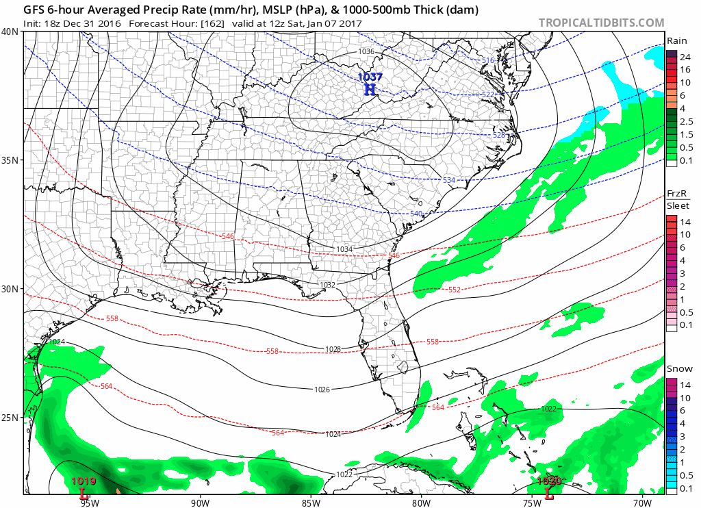
12Z (6 AM CST) run of the GFS valid for 6 AM Saturday morning showing precipitation type and rate. Image from TropicalTidbits.com

12Z run of the GFS showing accumulated snowfall through 12Z (6 AM CST) Sunday. Image from TropicalTidbits.com
Now, if you've been browsing Twitter or Facebook, you may have seen an image similar to one of the images I posted above. Unfortunately, many see this map and take it at face value. However, there are several things you need to consider before taking this map for what it's worth. Don't get me wrong, maps like this are useful, but only if they're used correctly.

It's Not All Snow

One big problem with the GFS is that it cannot tell the difference between snow, sleet, freezing rain when totaling up snow accumulation. So, it's hard to know exactly how much snow will fall, how much sleet will fall, or how much ice will accumulate. Thus, totals are often inflated more in these messy mixed-precipitation events. To determine our precipitation type (abbreviated P-Type from here on), we have to look at one of my favorite things, a skew-T.

Skew-T taken from the GFS model near Montgomery, Alabama, for 6 AM Saturday. Thin red line is the temperature through the atmosphere, and the thin green line is the dew point profile. This skew-T (and the next 4) is from pivotalweather.com, with my annotations drawn.
So, allow me to explain this as briefly as I can. We have to start in the mid-levels of the atmosphere to see if there is enough moisture to produce snow, sleet, etc. We look for where the temperature is between -12 degrees Celsius and -17 degrees Celsius (snow growth region), since that is the optimal ice crystal growth area. If that has enough moisture, then we can assume that ice crystals can/will form. In Montgomery's case, it's completely saturated in the snow growth region. Proceeding downward in the atmosphere, we look for any layers that are above freezing (0 degrees Celsius) that could melt the ice crystal. In this case, there aren't any. Next, we look at the surface temperature to see if it's below/at/above freezing. For Montgomery, the GFS says that it is below freezing. Thus, the ice crystal never melts, and the P-Type is likely snow.


This skew-T is from Evergreen, Alabama, valid at 6 AM Saturday. As with Montgomery, the snow growth region is forecast to be completely saturated. Further down in the atmosphere, there is a slight warm layer that is above freezing. This will allow for some melting, but not enough to fully disrupt the ice crystal. It then passes through a sub-freezing layer, which refreezes the partially-melted crystal. The surface temperature is forecast to be below freezing. All things considered, the likely P-Type is sleet (ice pellets).


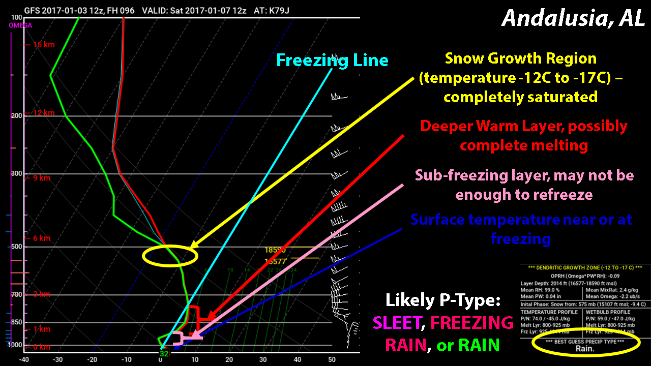
This skew-T is from Andalusia, Alabama, at 6 AM Saturday. As with the previous 2 soundings, the snow growth region is completely saturated. However, there is a deeper warm layer that warms to about 1 or 2 degrees Celsius. This may be enough to completely melt the ice crystal. It then passes through a shallow sub-freezing layer. If it only partially melts, it may refreeze and fall as sleet. If not, then it will either be freezing rain or just rain. The surface temperature is forecast to be at or just above freezing. If the surface temperature is at freezing, then the likely P-Type will likely be sleet (if it refreezes just above the surface) or freezing rain (if it melts completely). If the surface temperature is above freezing, then the P-Type will be plain old rain


Crestview and Destin are very similar to each other on the skew-T's. Both have lower moisture in the snow growth region. If anything forms, ice crystals in both locations pass through a substantial warm layer, which will melt any ice completely. Both soundings have little to no sub-freezing layer, so no refreezing will occur. Also, both locations have forecast temperatures above freezing. So, according to this, the P-Type for both locations would be (a very cold) rain.

So that covers precipitation type, but there are two more things that I want to cover.

Run-to-Run Inconsistency

An animation showing the last 12 runs of the GFS valid for 12Z (6 AM CST) Saturday. Animation from TropicalTidbits.com
One thing we meteorologists look for is some form of consistency in the models from run-to-run. The more it stays the same, the more confidence we can have in the forecast. Over the last 12 runs (3 days), the system that is forecast to impact the Southeast this weekend has jumped all over the place from run to run, which raised questions about what would actually happen. Only in the last few runs has it become more consistent, and confidence has increased a bit. Being 4 days out, changes are still possible, so we can't take any one run of any one model and run with it. We have to watch for consensus among the models and consistency within the models.

Know Your Sources

With the advent of social media, anyone (and I mean anyone) can get online and post a picture of a computer model. However, the difference is the explanation behind it. Now, I know some people who post these things are truly fascinated in the weather and possibly want to pursue their dreams. I know that they want to be like the meteorologist he/she admires. I think all of us meteorologists were there at some point, trying to mimic what our favorite meteorologist did. Others, however, do it for the hype behind it. They try to get as many likes or shares on Facebook and Twitter as they possibly can by using clickbait and over-exaggeration to get people to see it and believe them. I recommend that, if you see a post that you aren't sure about, ask a meteorologist who will have more insight on the situation. I can guarantee you we are looking at the same things you are and that they are. Just be careful who your sources are. I wrote a piece on this a while back when talking about the tropics, but it still applies. Read it here.

So, for the TL;DR (too long; didn't read). It looks increasingly possible that wintry weather could impact the Southeast. However, be wary of model snow maps as they are not always what they seem. Also, know your sources, and make sure you trust them enough to provide you with important information.

I do not think we will see much, if any, wintry precipitation in Northwest Florida at this time. If any were to occur, I think it would likely be in the form of freezing rain, especially closer to Century and Jay. The GFS Ensembles valid at Eglin AFB, Florida, only gives a 5% chance of measurable freezing rain (shown below). But, the forecast can (and probably will) change, and I will update my Facebook and Twitter to account for any changes.

from: http://www.emc.ncep.noaa.gov/mmb/cguastini/gefs/EMCGEFSplumes.html