Showing posts with label Weather. Show all posts

Monday, January 23, 2017

NW Florida Weather - Severe Weather Recap

After 3 rounds of severe weather within 2 days here in Northwest Florida, we definitely need a break from the severe weather, and it looks like we will get that. Sunshine and near-normal temperatures can be expected for the next several days (except Wednesday when we could see some showers and warm temperatures).

Below is a recap of the severe weather reports received through the weekend:

Green = Hail; Blue = Wind Damage/Gusts; Red = Tornado/Funnel Cloud/Waterspout

Saturday, January 21, 2017

Time
Location
County
Observation
Description
10:31 AM
4 mi. ENE of Dean Church Road
Walton
Unknown
Tree down on power line on Spring Lake Road.
10:40 AM
6 mi. W of Destin
Okaloosa & GMZ655
Waterspout
Report of two waterspouts off the coast of Okaloosa Island.
7:49 PM
2 mi. NNW of Pace
Santa Rosa
1.25” Hail
One to two inch hail reported near Pace. Time estimated via radar.
8:00 PM
Walnut Hill
Escambia
2.00” Hail
Reports of measured 2 inch hail near Walnut Hill.

Sunday, January 22, 2017


8:45 AM
1 mi. S of Navarre
Santa Rosa
1.00” Hail
Quarter sized hail in Navarre, FL
9:25 AM
Fort Walton Beach
Okaloosa
1.00” Hail
Quarter sized hail. Pictures from social media.
9:32 AM
Cantonment
Escambia
1.00” Hail
Quarter sized hail in Cantonment.
9:34 AM
4 mi. SSW of Fort Walton Beach
Okaloosa & GMZ655
Waterspout
Waterspout reported from Hurlburt Field ASOS.
10:10 AM
DeFuniak Springs
Walton
1.00” Hail
Photo received via email.
10:30 AM
4 mi. E of Brent
Escambia
Funnel Cloud
Funnel cloud seen near Spanish Trail Rd. via video on social media.
10:30 AM
2 mi. SW of Eglin AFB
Okaloosa
Unknown
Large tree limb snapped in Shalimar, FL.
10:48 AM
4 mi. W of Fort Walton Beach
Okaloosa
1.00” Hail
Hail on Hurlburt Field. Pictures via social media.
12:00 PM
DeFuniak Springs Airport
Walton
Unknown
Multiple trees and power lines down in DeFuniak Springs and Freeport. Time based on radar and operator logs.
1:00 PM
Panama City Airport
Bay
Unknown
Multiple trees and power lines down in greater Panama City area.
1:00 PM
Vernon
Washington
Unknown
Multiple reports of trees down countywide. Time estimated using radar and operator logs.
1:00 PM
Bonifay
Holmes
Unknown
Multiple trees down countywide. Time estimated using radar and operator logs.
1:04 PM
Tyndall AFB
Bay
68 mph
68 mph wind gust reported at the drone runway.
1:30 PM
Clarksville
Calhoun
Unknown
Multiple trees and power lines down countywide
1:34 PM
Marianna
Jackson
58 mph
58 mph wind gust reported at Marianna Municipal Airport
1:34 PM
Marianna
Jackson
Unknown
Several trees down countywide. Time estimated using radar, operator logs, and KMAI wind data.

Wednesday, January 18, 2017

NW Florida Weather - Rounds of Severe Weather

Residents of Northwest Florida will have to deal with a couple rounds of severe weather through this weekend. First, we will talk about Thursday's severe weather risk.

THURSDAY - January 19th

Storm Prediction Center (SPC) Convective Outlook with a zoom on Northwest Florida. Valid from 6 AM CST Thursday until 6 AM CST Friday.
The Storm Prediction Center has outlined the western half of Northwest Florida (Escambia, Santa Rosa, and Okaloosa Counties) in a "Marginal Risk" of severe weather (green-shaded area). This is a Level 1 out of 5 with 5 being the highest. The main threat will be an isolated damaging wind gusts. The tornado threat is very low, but not zero. Thus, I cannot rule out an isolated tornado. Timing appears to be Thursday late afternoon into Thursday night.

(from PivotalWeather.com) NAM 4 km model forecast radar valid from 6 AM CST Thursday until 6 AM CST Friday.
As the storms move from west to east, they will gradually weaken, resulting in a slightly better chance of severe weather over the western parts of Northwest Florida. However, that does not mean strong storms can be ruled out. Even if you aren't in the marginal risk zone, storms can still contain gusty winds and dangerous lightning. Rainfall totals are not expected to be impressive, on the order of 0.5 to 1 inch.

SATURDAY & SUNDAY - January 21-22


SPC Convective Outlooks for Saturday (top) and Sunday (bottom). Yellow-shaded area delineates 15% severe risk, which is equivalent to a slight risk (level 2 out of 5).
Saturday and Sunday could pose a "significant" severe weather risk, as the National Weather Service in Mobile stated. It is possible that the severe risk could start earlier, maybe Friday night. It currently appears that there could be 2 rounds of severe weather here in Northwest Florida. The first may come Friday night into Saturday morning as a warm front moves northward. In the vicinity of the warm front, there will be sufficient shear and sufficient helicity (turning of the winds, spin) to support a severe weather risk. Here is an excerpt from the NWS Mobile's forecast discussion from Wednesday afternoon:
Based on the timing of the best deep layer lift, which includes a bit
of a respite around midday Saturday, expect a round of severe
weather late Friday night through Saturday morning as the warm front
lifts northward through the area, followed by a second round of
severe weather developing Saturday afternoon and continuing through
Saturday night.
The second round of severe weather for this weekend comes in during Saturday afternoon. Tornadoes, damaging winds, and large hail will all be possible with this weekend's severe weather risk. Through Sunday morning, we continue the severe weather risk, although it may be slightly lower than the risk on Saturday afternoon. However, all modes of severe weather will be possible (tornadoes, damaging winds, large hail).

A more detailed analysis of this weekend's severe weather risk will be posted either tomorrow and/or Friday. If severe weather is a bit lackluster on Thursday, I will have another post tomorrow afternoon or evening. This post may or may not happen, depending on how tomorrow's weather unfolds. Friday, there will be a forecast update regarding this weekend's severe weather risk. For quick updates, you can always visit my Facebook or Twitter pages.

Wednesday, December 14, 2016

Northwest Florida Weather (12-14-2016) - All Aboard the Roller Coaster!

Living in Northwest Florida, the wintertime is a roller coaster ride when it comes to the weather. Some days, it's warm enough to go to the beach. Others are days where you'd rather stay in bed with multiple blankets. Unfortunately, the next seven days feature days to satisfy both the beach days and the bed days (probably not all that great for colds either). However, a single seven-day forecast (or, in my case, two seven-day forecasts since I do both inland and coastal seven-days) just doesn't show you all the detail. They could, but they quickly become crowded. Thankfully, I am not having to include wintry precipitation in our forecast, so that makes my life (and your life) much easier. Below, I will show each of the seven days and give you a brief discussion about the forecast.

THURSDAY:

Thursday will feature colder temperatures than we have seen lately. We've been well into the 70s and even near 80 for a few days now, so 50s and 60s will be a shock to the system. Keep in mind, this is about 5 degrees below normal for this time of year. It will be a bit breezy, too, so that will make it feel a bit colder. At least it will be sunny, right?

Thursday night will be cold. Lows will be near freezing, and even below in some spots (I'm looking at you, Crestview). Coastal areas will escape the coldest temperatures, but will still be near 40. Clear skies, and winds will be calming down.

FRIDAY:

Friday is a day of change. Just as quickly as we went down, we go right back up. A few clouds will dot the sky on Friday, gradually increasing into the nighttime hours. Notice that the winds have shifted to out of the southeast, now, which helps bring in warmer temperatures. Highs on Friday will be near to slightly above normal with temperatures in the mid 60s.

The southeasterly wind will continue to bring in warmer temperatures through the night. We fall to our lows early in the night on Friday, so those upper 50s and lower 60s may occur closer to midnight, then gradually increase to the upper 60s/near 70 by Saturday morning. Clouds will increase through the night as well.

SATURDAY:

Saturday will be the warmest day in the forecast, with temperatures approaching record levels. The record high for Pensacola (the official climate reporting station in Northwest Florida) is 78. We'll be close, and we could even hit 80 in some inland areas, especially if a bit more sunshine pokes through the clouds. This is one of those days that could be a good beach day, barring the fact that the rip current risk will likely be moderate to high and water temperatures in the 60s. Skies will remain generally cloudy during the day, and winds will also pick up. There is only a 20% chance of a shower during the day.

Saturday night, rain chances increase ever so slightly, especially the farther west you are (areas such as Pensacola, Century, Jay, and Milton). Very warm overnight lows are expected with temperatures in the mid to upper 60s. Now, here is an interesting fact: those overnight lows are above the normal high for this time of year.

SUNDAY:

Sunday is yet another day of change. Rain and thunderstorms look likely. Right now, it's too early to give specifics on a severe weather threat, but we will have to continue monitoring. We will know more once we get closer to Sunday. However, the cold front is expected to pass through during the day, hence the winds shifting from southwest to north. The further west you are, the more likely your temperatures will fall during the afternoon. If you are further east, your temperatures will fall quite a bit during the evening as the cold front moves through. Either way, the highs marked here are averages for the area. The further west you are, highs may be in the upper 60s/lower 70s. The further east you are, highs may be in the mid to upper 70s.

For Sunday night, thunderstorms will end during the evening, but we could still have showers overnight. Lows will be nearly 20 degrees cooler than Saturday night with temperatures in the upper 40s to lower 50s. Winds will be rather breezy, ushering in the colder air.

MONDAY through WEDNESDAY:


The early part of next week is generally constant as far as weather goes. There is still a good chance of rain on Monday as leftover moisture just lingers over the area. It will be much cooler, so this is a day that you would want to stay in bed. Basically, it will truly feel like a Monday. Highs will only manage the mid to upper 50s. Rain chances gradually decrease Tuesday and Wednesday as temperatures start to warm back up. Highs by Wednesday will be in the mid 60s and lows will be in the 50s. Winds on Wednesday night will shift back out of the southeast ahead of potentially another system, but that's too far out to even think about speculating.


Remember, for more frequent updates, you can follow my social media sites:

Tuesday, November 29, 2016

Northwest Florida Weather (11/29/2016) - Another Severe Weather Threat

Before I begin this blog post, I'd like to extend my sincerest thoughts and prayers to those in Gatlinburg, Pigeon Forge, and surrounding areas that were affected by the wildfire. Extremely sad situation with loss of life. I'm thankful, as I'm sure many are, for the first responders' and emergency personnel's acting quickly as it could have been a lot worse.

Now, back to Northwest Florida weather information.

Well, frankly, last night ended up being a lack of rain for most areas. The good news is that we didn't have any severe weather in our area, but the bad news is that most areas didn't get much rain, if any. Why was that?

Well, last night, we were lacking instability, which some models were not picking up on. The line of storms was forecast to weaken as it moved further east, but the actual line weakened sooner than what models were thinking. Most of the better lift and instability was to our north and away from us in Northwest Florida.

So, what about tonight and tomorrow?

The Convective Outlook issued by the Storm Prediction Center (SPC). This map is valid through 6 AM CST Wednesday morning.
Parts of Northwest Florida are in the "Marginal Risk" of severe weather. This is a Level 1 out of 5, meaning we could get some isolated severe thunderstorms. But, what severe weather we might get would be closer to 6 AM Wednesday.

SPC's Convective Outlook for 6 AM Wednesday through 6 AM Thursday.
SPC has place all of Northwest Florida under a "Marginal Risk" for Wednesday. This again is a Level 1 out of 5. Isolated severe thunderstorms will be possible, with damaging winds being the main threat with any severe thunderstorms. Let's talk some meteorology!

Model sounding from the HRRR (High-Resolution Rapid Refresh) Model valid at 11 AM CST Wednesday at KVPS (Eglin AFB, FL). Focusing mostly on the left half of the image. The solid red line is the temperature profile through the atmosphere, the solid green line is the dew point profile. Pressure is labeled in millibars on the left, decreasing with height. Temperatures are labeled on the bottom in degrees Celsius. Multiple parameter are located at the bottom of the image. Image courtesy of pivotalweather.com and SHARPpy.
I personally think these model soundings are a meteorologist's best friend. There's just an abundance of information you can get from these. So, let's see what there is to see.

  • Generally, there is atmosphere is abundantly moist, especially at/below 700 mb. There are two ways we can see this. First, the temperature and dew point lines are pretty close together. Second, the precipitable water (labeled PW in the parameters table) is around 1.67 inches, meaning the atmosphere is sufficiently moist. Note about the precipitable water: Basically, it's how much water would accumulate if all the moisture in the atmosphere above a point was wrung out. The moisture allows for cloud and precipitation development. Also, the more moist the atmosphere is, the higher possibility of heavy rainfall, and the rainfall can help transfer some higher winds aloft to the surface ("waterloading")
  • Warm air advection through the lower portion of the atmosphere. This is a lifting mechanism. Warm air is less dense and warm air can rise.
  • CAPE is high, meaning plentiful instability, allowing air to rise easily.
  • Decent shear, which is favorable for thunderstorm development.
  • Dry adiabatic layer from about 900 mb to the surface. (Dry adiabatic layer means that the temperature profile is parallel to the dry adiabatic lapse rate, denoted by the thin diagonal white lines going up and to the left. The dry adiabatic lapse rate is the rate at which the atmosphere cools as you proceed upward in the atmosphere if the atmosphere is not saturated.) This will allow winds to be transported downward more easily.
One note, the sounding algorithms do spit out a "possible hazard type" of tornado. I use this only as a worst case scenario. This should not be taken as there gospel truth.

So, the signals are good for at least thunderstorms, and maybe some severe storms. But there are a couple of caveats.
  • Helicity is not all that impressive, meaning that there is not as much spin in the atmosphere. Thus, it does not lend itself to an atmosphere supportive of tornadoes. That's not to say it can't happen, but it's less likely.
  • This model assumes that the temperature will make it to near 80 degrees at the surface. I'm not fully confident in that solution. I do think it will be warm, but I'm not sure about it being that warm. This affects CAPE, low level moisture, and that dry adiabatic layer.
Here is what the HRRR model (the same one the sounding is from) predicts the radar will look like:

HRRR predicted 1 km reflectivity valid from 8 PM CST Tuesday through 11 AM CST Wednesday.
The HRRR only goes out 18 hours. It shows a line of thunderstorms (potentially strong to severe) entering Northwest Florida around 9 AM (+/- 2 hours). But the general trend looks to be slow weakening as it moves further east.

So, again, this is just one run of one model. Just one tool in our toolbox. Let's take a look at one other model.

This is a model sounding from the NAM valid at 12 PM CST Wednesday. Same properties as the sounding above.
So, just like the HRRR, the NAM has abundant moisture, warm air advection, decent CAPE (for this time of year), and decent shear. Now, there are a few differences. It's not as warm at the surface, thus nearly eliminating the dry adiabatic layer. Speaking of which, it looks like the dry adiabatic layer is only from 975 mb to the surface, not nearly enough for easily transporting winds from aloft to the surface. But, there is more helicity than there was in the HRRR sounding, meaning more possibility for rotation. So, what does this mean?

With lower instability, we may not see as much thunderstorm development. With fewer thunderstorms to tap into that helicity, the threat of tornadoes is lower. There could still be damaging winds with stronger storms. But what does the predicted radar look like with the NAM?

NAM predicted radar valid from 9 PM CST Tuesday through 9 PM Wednesday.
The NAM does not have as much in the way of intense convection (meaning that it may not be predicting as much thunderstorm activity). The NAM also brings in the convection later than the HRRR, closer to 12 PM. But the general trend is the same, weakening as it moves further east.

So what does this all mean for your forecast? We will probably see more scattered showers around Northwest Florida tonight, not really expecting much in the way of thunderstorm activity tonight, but can't rule out an isolated storm. Severe weather is not expected tonight. Wednesday is our better chance of rain. Showers and thunderstorms look to move into Northwest Florida during the mid to late morning and move eastward. The general trend is for the line to weaken as it moves further east. An isolated severe thunderstorm or two cannot be ruled out with damaging winds being the main threats. Widespread severe weather is not expected in our area.

Monday, November 28, 2016

Northwest Florida Weather - Rain Brings Good News and Bad News

Total rainfall through midnight Wednesday night predicted by the NAM (North American Mesoscale) model.
There is a good chance of something we haven't seen much of in Northwest Florida for quite some time. Rain! While this likely won't be drought-busting rain, 0.5 to 1 inch is not out of the question during the next couple of days. And, besides, it's more rain than we've seen in quite some time. Unfortunately, there is a down side to this rain, and that's the possibility of severe weather.

The Convective Outlook from the Storm Prediction Center (SPC) showing the possibility of severe weather across the state of Florida. This map is valid until 6:00 AM CST Tuesday.
Yes, we have the potential of severe weather tonight (Monday night) into Tuesday morning here in northwest Florida. The Storm Prediction Center (SPC) has outlined areas generally west of Highway 331 (including Escambia, Santa Rosa, and Okaloosa Counties) in a "Marginal Risk" of severe weather, meaning that isolated severe thunderstorms are possible in that area. This risk is valid through 6 AM Tuesday morning. The environment isn't too supportive of severe weather for tonight, but some thunderstorms are in the forecast. Let's take a dive into a bit of meteorology.

from pivotalweather.com & SHARPpy. This is a model sounding from the HRRR (High-Resolution Rapid Refresh) model. The solid red line in the upper left diagram is the temperature profile through the atmosphere, and the solid green line is the dew point profile. The closer the lines are to each other, the more moist the atmosphere is. On the left, the pressure levels are labeled in millibars (mb) decreasing with height, and the temperatures are labeled on the bottom in degrees Celsius. Winds are labeled on the right hand side of the upper left diagram in knots.
This model sounding (from SHARPpy) shows what the HRRR thinks the atmosphere will look like at 3 AM CST at KVPS (Eglin AFB). Let's go through some things working in favor of severe weather tonight.

  • Sufficient moisture at and below 700 mb.
  • Strong winds around 850 mb (winds around 40-45 knots, 45-50 mph)
  • Warm air advection
  • Sufficient helicity
  • Sufficient shear
  • Decent instability
So, we pretty much checked off all of our severe weather ingredients. But, keep in mind, this is just one run of one model, and the atmosphere doesn't always behave like we want it to. Let me discuss a bit about models. Models ingest data before their run. The model already has its initial forecast planned out, then it uses the observations and data it ingests to adjust its forecast. The model can either adjust its forecast to come closer to the observation or reject the observation. The model rarely, if ever, accepts an observation as absolute truth. This already causes inherent error. Plus, observations aren't taken everywhere, especially upper air observations. Thus, we as meteorologists have to try to figure out if the model is performing well with interpreting and interpolating data. You can see where a lot can go wrong already, but this topic is for another time. Back to severe weather.

So, with one run of one model, it looks like severe weather is a decent possibility. One thing to note is that this sounding indicates a "possible hazard type" of tornado. I generally use the "possible hazard type" as the worst-case scenario of what could happen. Remember, that is also dependent on if there are storms around. Let's look at the same model run to see what it predicts as far as future radar.

Same run of the HRRR as the model sounding came from. This is the 1 km above ground level reflectivity forecast. Essentially, this is a future radar product. This is valid through 9 AM CST Tuesday morning.
The model shows a broken line of showers and thunderstorms moving through the Florida Panhandle early Tuesday morning. Now, notice that the line in general appears to weaken as it moves further east. So, if you're in Panama City or Marianna, your severe weather chance will be lower. Before we move on, let's look at one more just to show the uncertainty.
This is the 4 km NAM (North American Mesoscale) model valid through 9 AM CST Tuesday. Showing the same product as depicted in the HRRR model animation.
You can see, this model nearly completely dissipates the line of storms before getting here. This is why there's still quite a bit of uncertainty, even in the short term forecast.

Overall, I think our severe weather threat is low tonight and tomorrow morning. Gusty winds will be the main threat with the stronger storms tonight. I can't fully rule out an isolated tornado, but I think the better chance of that happening would be to our north and west.

Going into Tuesday and Wednesday, we still do have a risk of severe weather across northwest Florida. Here are the convective outlooks from the Storm Prediction Center.

SPC's convective outlook valid from 6 AM Tuesday through 6 AM Wednesday.


SPC's convective outlook valid from 6 AM Wednesday through 6 AM Thursday
The second threat of severe weather looks to be primarily Wednesday morning across northwest Florida. Again, damaging winds look to be the primary threat with severe thunderstorms. An additional blog post will be published on this possible severe weather threat tomorrow afternoon.

Thursday, November 17, 2016

Northwest Florida Weather - 11-17-2016 - Drought Worsens with Little to No Relief


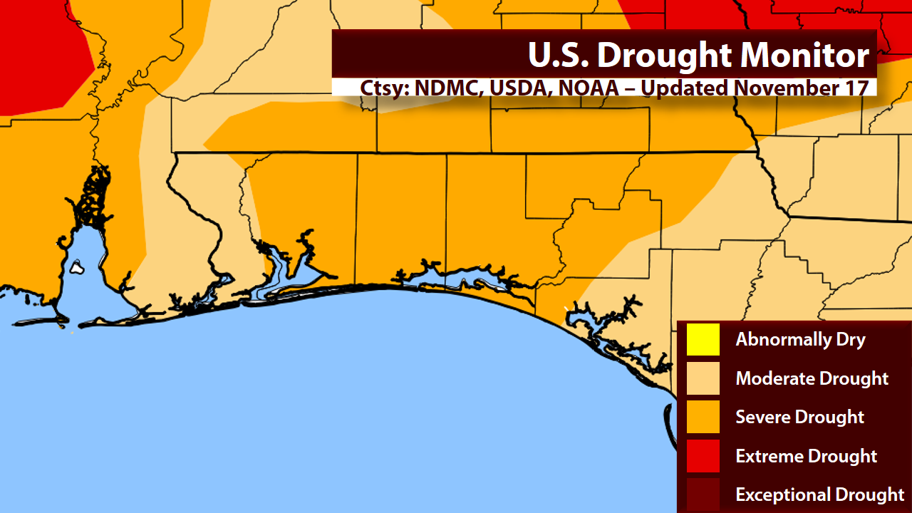
Latest Drought Monitor for Northwest Florida. Map data provided by the National Drought Mitigation Center (NDMC), United States Department of Agriculture (USDA), and the National Oceanic and Atmospheric Administration (NOAA).
The latest drought monitor was released today, and it does not bring good news. Unfortunately, the drought has worsened. Much of Northwest Florida is now in a "Severe Drought." While there are no official burn bans in effect right now, outdoor burning is strongly discouraged. In fact, the Florida Forest Service is not issuing any authorizations for acreage or pile burning in the Blackwater Forestry District (Escambia, Santa Rosa, and Okaloosa Counties). The drought is highly affecting our soil moisture as well.

The Keetch-Byram Drought Index (KBDI) essentially measures the soil moisture. Above is the average value by county across Northwest Florida.
This is the Keetch-Byram Drought Index (KBDI) data from the Florida Forest Service. The KBDI assumes that the top 32 inches of soil can hold up to 8 inches of water. A KBDI of 0 means that the soil is water-logged and can't hold any additional water; on the other hand, A KBDI of 800 means that the soil is completely dry. Right now, Okaloosa, Walton, and Holmes Counties are the driest counties not only in Northwest Florida, but the entire state. This dry soil can lead to an enhanced wildfire danger. Unfortunately, there is very little in the way of rain in the forecast.

12Z (6 AM CST) run of the GFS model. Black solid lines represent isobars (lines of constant pressure). Red and blue dashed lines represent 1000-500 mb thickness. Shaded areas represent 6-hour precipitation accumulation. Fronts drawn in by myself.
While we do have a cold front moving through, it looks like rain will fall apart as it approaches. I am forecasting only a 10% chance of rain, and that might be a bit optimistic. Even if we do see rain, totals will be less than 0.10". Very dry air will follow behind the cold front as well as breezy conditions.

This is a model skew-T from the 12Z (6 AM CST) run of the GFS at KVPS (Destin-Fort Walton Beach Airport). Focus on the upper left diagram. The dashed white diagonal lines are temperatures in degrees Celsius. The solid white horizontal lines are pressure. As you head up the diagram, you go up in the atmosphere, and pressure decreases. The solid red line is the temperature profile through the atmosphere, and the solid green line is the dew point profile through the atmosphere.
Let's look at the above model skew-T. This is valid as of noon CST on Sunday at the Destin-Fort Walton Beach Airport in Valparaiso. It will be rather cool with this particular model only showing mid-50s at the surface at this time. But check out the dew point: 11 degrees Fahrenheit. That is bone-dry. If we go up just a little bit in the atmosphere (roughly 4,500 to 5,000 ft.) at 850 mb, it's even drier. The temperature at 850 mb is 47.3 degrees F., but the dew point is -35.5 degrees F. That is an 82.2 degree difference between the temperature and dew point.

After a bunch of math that I won't bore you with, you get this:
Relative humidity at the surface: 16.4%
Relative humidity at 850 mb: 2.2%

In other words, very, very dry conditions are expected after the cold front passes through. That coupled with winds around 10 mph could produce very dangerous conditions for wildfires. Fire Weather Watches or Red Flag Warnings may become necessary.

But that's not the only threat. Some of the coldest air of the season so far will be filtering in behind this front. Many areas could see their first freeze of the season. Here is a look at Saturday Night's forecast:


This already would be the coldest air of the season for most areas. Widespread 30s can be expected across much of Northwest Florida. But, the winds will prevent the temperatures from falling below freezing for most places. Now, not to outdo Saturday night, here's Sunday Night's forecast:


Even colder temperatures possible on Sunday night. With decreasing winds, it will allow our temperatures to fall quite a bit more. Many areas north of the bays could see their first freeze of the season. The National Weather Service in Mobile (which covers Escambia, Santa Rosa, and Okaloosa Counties) said this in their latest forecast discussion:

It will then be dry and cold over the weekend in the wake of the front and surface high
pressure building in from the north. Will monitor for likley [sic] Freeze
Watches and Warnings over the weekend...
Low temperatures Saturday night behind the cold front will fall into
the mid to upper 30s, with lows Sunday night ranging from 25 to 32
degrees inland areas, and from 32 to 38 degrees along the immediate
coast.
So, in summary, very little, if any, rain is expected through the weekend. A cold front will move through on Saturday, which will bring the coldest air of the season. Freeze Watches/Warnings will likely be issued this weekend. Very dry air and breezy conditions this weekend will lead to dangerous wildfire conditions, and Fire Weather Watches/Red Flag Warnings may be required.