DISCLAIMER: The views expressed in the blog post are strictly my own and do not necessarily express the views of the National Hurricane Center, National Weather Service, or other official sources unless explicitly stated. The ideas expressed here should not be the sole source of your information. Always consult official sources before making any decisions. |
| Tropical Weather Outlook from the National Hurricane Center showing our two areas of interest. Valid as of 7 PM CDT Friday (June 16, 2017). |
 |
| The climatologically-favored areas of tropical cyclone formation during June. Image from the National Hurricane Center. Source: http://www.nhc.noaa.gov/climo |
Invest 92L
 |
| Infrared satellite imagery of Invest 92L. Source: http://www.ssd.noaa.gov/PS/TROP/floaters.html |
Let's start with the system that has a higher chance of development in the short term--Invest 92L. Since this is one of the first times we're talking about "invests" this season, remember that an "invest" is an area of investigation. These are called 90L to 99L ("L" for Atlantic), and the numbers are reused through the season.
92L isn't looking too shabby, especially for June. This tropical wave came off the coast of Africa a couple days ago, and has maintained its organization fairly well. Here's the National Hurricane Center's outlook for 92L:
Satellite images indicate that an area of disturbed weatherConditions are expected to become less favorable for development in a few days as it approaches the Windward Islands. But it's still several days away from land--plenty of time to watch this. Just so you can see them, here are the spaghetti plots:
associated with a tropical wave is located about 1800 miles east of
the southern Windward Islands. This disturbance has become
better organized today, and additional development is possible
during the next day or two before conditions become less favorable
for tropical cyclone formation. This system is expected to continue
moving toward the west at 15-20 mph over the tropical Atlantic
during the next several days.
* Formation chance through 48 hours...medium...40 percent.
* Formation chance through 5 days...medium...60 percent.
 |
| Spaghetti models for Invest 92L (as of 7 PM CDT June 16, 2017). Source: http://www.tropicaltidbits.com/ |
- These are just one run of these models, and only give a general idea of it's potential movement. Thus they can change from run to run.
- These don't tell you about the possible intensity of whatever system.
- These don't tell you about any of the impacts, only about the center of the system.
Generally, the system is expected to move toward the southern Windward Islands, and maybe brush the northern coasts of Guyana and Venezuela, bringing some squally weather for those areas.
The Mess in the Caribbean
 |
| GOES-16 Infrared satellite imagery showing the Gulf of Mexico and the NW Caribbean Sea. Source: http://weather.cod.edu/satrad/exper/. NOTE: GOES-16 data is undergoing testing as is considered experimental and non-operational. |
Yes, I'm using "mess" as a technical term. This view doesn't even give the full view of the Caribbean Sea, but I used it because the GOES-16 imagery is meteorological awesomeness. Very high resolution and rapid data. But, let's give you a complete view of the Caribbean.
 |
| Infrared satellite imagery of the Caribbean Sea. Source: http://www.nhc.noaa.gov/satellite.php |
Here's the official word from the National Hurricane Season (as of 7 PM CDT, June 16, 2017):
Surface pressures are falling in the western Caribbean Sea and
the areal coverage of the disturbed weather has continued to
increase. Conditions appear to be favorable for gradual development
of this system while it moves slowly northwestward across the
Yucatan Peninsula this weekend and into the south central Gulf of
Mexico early next week. Regardless of development, heavy rains are
likely to spread over portions of Central America, the Yucatan
Peninsula and western Cuba during the next several days.
* Formation chance through 48 hours...low...20 percent.
* Formation chance through 5 days...medium...60 percent.
There's nothing organized about it at this time, and that's causing a lot of problems for forecasting. How? Allow me to explain.
Without anything defined in the Caribbean, the models can't lock on to anything, but they will try to make some sort of sense of what's going on with what data they have. Unfortunately, there isn't a whole lot of data in this area, so the model uses its own forecasts. This can lead to the model consistently performing poorly. Also, as of this writing, this area has not been designated an "invest" (again, due to the lack of an organized low pressure center). This means that we do not have spaghetti models to show you. Let's break down some models.
GFS
 |
| GFS model valid Monday morning. Model image source: tropicaltidbits.com. Annotations made by me. |
Okay, let's break down the image. The different color shadings represent the flow at 500 millibars (about 17,000 feet). I tried to illustrate the flow using the black and white arrows. Our surface low is the red and white "L."
The GFS predicts that there will be a ridge from Texas westward (part of what will bring record heat to the Desert Southwest) and another ridge from the East Coast into the Atlantic (ridges = high pressure = "H"). However, there is a bit of a break, or "weakness" in the ridge. This may help draw the low pressure system further north.
 |
| GFS model valid Wednesday morning. Model image source: tropicaltidbits.com. Annotations made by me. |
By Wednesday morning, a trough dips down, according to the GFS, and starts to pick up the low pressure system and starts lifting it northeastward while it weakens further. The low at this point is relatively weak, but the main threat would not be wind, but would be heavy rain according to the GFS.
 |
| GFS model precipitation through Thursday afternoon. Model image source: tropicaltidbits.com. |
Wherever this system goes, the eastern and northern sides will see quite a bit of rain. The GFS paints well over 6" of rain over the Big Bend of Florida through Thursday afternoon.
But, if you read my posts, you know that I am quick to point out to never use one run of one model. So, let's take a look at what the past runs have done with this system.
 |
| GFS model trend using the last 10 runs, all valid for Wednesday morning. Model image source: tropicaltidbits.com. |
The last 10 runs of the GFS haven't been exactly consistent, ranging from the low being in the southwestern Gulf to northwest Florida in just 10 runs. However, it is somewhat consistent in strength, keeping it weak. But, again, we don't have an organized system to pinpoint yet, so we don't know if this model (or any of its runs) will be correct.
Let's take a look at another reliable model...
ECMWF (European)
 |
| ECMWF model valid Monday morning. Model image source: tropicaltidbits.com |
The ECMWF, another reliable model, shows that the ridging is a bit stronger than the GFS. The result? Any northward motion gets blocked since there's little to no weakness. It gets shoved to the west. So what happens further down the line?
 |
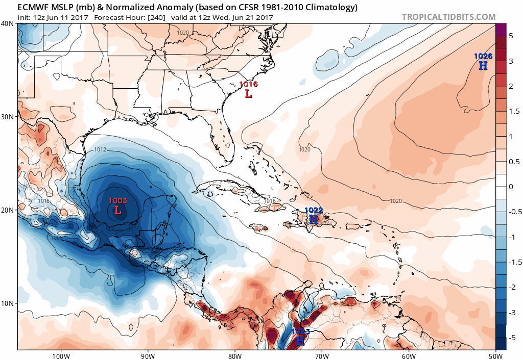
| ECMWF model valid Wednesday morning. Model image source: tropicaltidbits.com |
It moves toward Mexico instead of the northern Gulf Coast. The mid to upper level flow blocks any northward progression.
However, a lot of moisture will still be drawn up from the Caribbean, and very heavy rain would still happen to the east and north of the center. I can't show the precipitation data from the ECMWF due to proprietary issues. But how consistent has the ECMWF been?
 |
| ECMWF model trend of last 6 runs, all valid Wednesday morning. Model image source: tropicaltidbits.com |
Actually, the ECMWF has been relatively consistent in placement and strength. But does that mean that it's more accurate? Not necessarily, and only time will tell what actually happens.
One last model (or set of models) to show you.
GFS Ensembles (GEFS)
 |
| GFS Ensembles showing different low positions from Sunday afternoon through Wednesday afternoon. Model image source: tropicaltidbits.com |
You've actually seen this model before, sort of. This is the GFS model run several times, each time being tweaked slightly. This results in different outcomes. Each red number you see is a low pressure center that each run produced. The more clustered they are, the more confident the model is in that solution. The more spread out they are, the more uncertain the forecast. The GFS Ensembles are actually fairly consistent in the central Gulf of Mexico, but it quickly become uncertain, and it has to do with the ridge and/or weakness we've seen in the other discussions.
Summary
So, you've read this far, what are the takeaways?
- Invest 92L is still really far away from land, and won't bother anyone for several days. But it does have a 60% chance of formation during the next 5 days.
- The mess in the Caribbean is just that right now, a mess.
- There is much uncertainty in the forecast with the mess in the Caribbean. Part of this is due to nothing being organized right now. Another factor is its large size. It takes longer for larger systems to become organized.
- The models are very split as to what will actually happen.
So, what should you do?
- Don't panic! There's still time to watch what will happen.
- Keep up with forecasts this weekend.
- Consult official sources when making any decisions.
- Now is a good time to review your emergency plans and make sure your kit is stocked. You can never be over-prepared!
No comments:
Post a Comment