 |
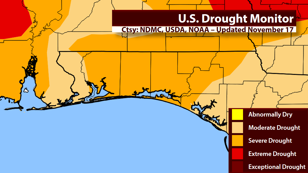
| Latest Drought Monitor for Northwest Florida. Map data provided by the National Drought Mitigation Center (NDMC), United States Department of Agriculture (USDA), and the National Oceanic and Atmospheric Administration (NOAA). |
 |
| The Keetch-Byram Drought Index (KBDI) essentially measures the soil moisture. Above is the average value by county across Northwest Florida. |
 |
| 12Z (6 AM CST) run of the GFS model. Black solid lines represent isobars (lines of constant pressure). Red and blue dashed lines represent 1000-500 mb thickness. Shaded areas represent 6-hour precipitation accumulation. Fronts drawn in by myself. |
 |
| This is a model skew-T from the 12Z (6 AM CST) run of the GFS at KVPS (Destin-Fort Walton Beach Airport). Focus on the upper left diagram. The dashed white diagonal lines are temperatures in degrees Celsius. The solid white horizontal lines are pressure. As you head up the diagram, you go up in the atmosphere, and pressure decreases. The solid red line is the temperature profile through the atmosphere, and the solid green line is the dew point profile through the atmosphere. |
After a bunch of math that I won't bore you with, you get this:
Relative humidity at the surface: 16.4%
Relative humidity at 850 mb: 2.2%
In other words, very, very dry conditions are expected after the cold front passes through. That coupled with winds around 10 mph could produce very dangerous conditions for wildfires. Fire Weather Watches or Red Flag Warnings may become necessary.
But that's not the only threat. Some of the coldest air of the season so far will be filtering in behind this front. Many areas could see their first freeze of the season. Here is a look at Saturday Night's forecast:

This already would be the coldest air of the season for most areas. Widespread 30s can be expected across much of Northwest Florida. But, the winds will prevent the temperatures from falling below freezing for most places. Now, not to outdo Saturday night, here's Sunday Night's forecast:

Even colder temperatures possible on Sunday night. With decreasing winds, it will allow our temperatures to fall quite a bit more. Many areas north of the bays could see their first freeze of the season. The National Weather Service in Mobile (which covers Escambia, Santa Rosa, and Okaloosa Counties) said this in their latest forecast discussion:
It will then be dry and cold over the weekend in the wake of the front and surface high
pressure building in from the north. Will monitor for likley [sic] Freeze
Watches and Warnings over the weekend...
So, in summary, very little, if any, rain is expected through the weekend. A cold front will move through on Saturday, which will bring the coldest air of the season. Freeze Watches/Warnings will likely be issued this weekend. Very dry air and breezy conditions this weekend will lead to dangerous wildfire conditions, and Fire Weather Watches/Red Flag Warnings may be required.Low temperatures Saturday night behind the cold front will fall into the mid to upper 30s, with lows Sunday night ranging from 25 to 32 degrees inland areas, and from 32 to 38 degrees along the immediate coast.
No comments:
Post a Comment