Showing posts with label North Carolina. Show all posts

Friday, September 2, 2016

Hermine Hugs the East Coast, Gaston Grazes the Azores, and Lester Looms Near Hawaii

It has been very active in the tropics. In fact, every tropical cyclone over the past several days in the central/eastern Pacific and the Atlantic has had at least one tropical storm or hurricane watch or warning:

  • Tropical Depression Eight (Atlantic) had Tropical Storm Warnings for the Outer Banks of North Carolina
  • Hurricane Madeline (now dissipated) had Hurricane Warnings and Tropical Storm Warnings for parts of Hawaii
  • Hurricane (now Tropical Storm) Gaston has Tropical Storm Warnings for portions of the Azores
  • Hurricane (now Tropical Storm) Hermine had Hurricane Watches and Warnings for parts of Florida and currently has Tropical Storm Watches and Warnings up and down the Eastern Seaboard
  • Hurricane Lester currently has Hurricane Watches for portions of Hawaii
So, let's start with the threat to the Azores: Tropical Storm Gaston

TROPICAL STORM GASTON


Well, Gaston's days are numbered. What was once an impressive major hurricane is now a nearly convectionless swirl. Here is the latest (11 PM AST) Advisory from the National Hurricane Center:

 
SUMMARY OF 1100 PM AST...0300 UTC...INFORMATION
-----------------------------------------------
LOCATION...40.1N 28.7W
ABOUT 105 MI...165 KM N OF FAIAL ISLAND IN THE CENTRAL AZORES
ABOUT 125 MI...200 KM NW OF LAJES AIR BASE IN THE AZORES
MAXIMUM SUSTAINED WINDS...40 MPH...65 KM/H
PRESENT MOVEMENT...ENE OR 70 DEGREES AT 16 MPH...26 KM/H
MINIMUM CENTRAL PRESSURE...1003 MB...29.62 INCHES


A Tropical Storm Warning remains in effect for Flores and Corvo in the western Azores, and for Faial, Pico, Graciosa, Sao Jorge, and Terceira in the central Azores. Gaston is expected to continue weakening and dissipate into a remnant low by Saturday. The saga of Gaston will soon come to an end.

HURRICANE LESTER


Lester is a Category 2 Hurricane moving to the north of Hawaii. However, Hurricane Watches continue for the islands of Maui, Molokai, Lanai, Kahoolawe, and Oahu. A Hurricane Watch means that hurricane conditions (winds of 74+ mph) are possible within the next 48 hours. Here is the latest information (5 PM HST) from the Central Pacific Hurricane Center:


SUMMARY OF 500 PM HST...0300 UTC...INFORMATION
----------------------------------------------
LOCATION...20.5N 151.0W
ABOUT 270 MI...435 KM ENE OF HILO HAWAII
ABOUT 450 MI...720 KM E OF HONOLULU HAWAII
MAXIMUM SUSTAINED WINDS...105 MPH...165 KM/H
PRESENT MOVEMENT...WNW OR 290 DEGREES AT 14 MPH...22 KM/H
MINIMUM CENTRAL PRESSURE...973 MB...28.74 INCHES
While Lester is expected to remain north of the Hawaiian Islands, gusty winds, possibly to near hurricane force, heavy rainfall, and dangerous surf are possible in Hawaii.

TROPICAL STORM HERMINE


Hermine roared ashore just east of St. Marks, Florida around 1:30 AM EDT Friday morning as a Category 1 Hurricane, packing winds of 80 mph. Hermine's landfall marked the end of the 3,966-day hurricane drought in Florida. Hermine produced record-breaking storm surge in Cedar Key, FL, and widespread tree damage in the Tallahassee area. Reports of tornadoes, flooding, and strong winds were reported across much of the state. Hermine moved into southern Georgia and eastern South Carolina through the day Friday, bringing strong winds and heavy rainfall. Now, Hermine is moving through portions of North Carolina as a mid-grade Tropical Storm. Here is the latest information (as of 11 PM EDT) from the National Hurricane Center:


SUMMARY OF 1100 PM EDT...0300 UTC...INFORMATION
-----------------------------------------------
LOCATION...34.1N 78.4W
ABOUT 30 MI...45 KM WSW OF WILMINGTON NORTH CAROLINA
ABOUT 180 MI...290 KM WSW OF CAPE HATTERAS NORTH CAROLINA
MAXIMUM SUSTAINED WINDS...50 MPH...85 KM/H
PRESENT MOVEMENT...NE OR 55 DEGREES AT 22 MPH...35 KM/H
MINIMUM CENTRAL PRESSURE...997 MB...29.44 INCHES
There are Tropical Storm Watches and Warning all up and down the East Coast. Here are the latest watches and warnings:

  • TROPICAL STORM WARNING: from Edisto Beach, SC, to Sandy Hook, NJ; for Pamlico and Albemarle Sounds; for Chesapeake Bay from Drum Point southward; for Tidal Potomac from Cobb Island eastward; for Delaware Bay
  • TROPICAL STORM WATCH: from north of Sandy Hook, NJ, to west of Watch Hill, RI
Hermine will move off the coast of the Mid-Atlantic by Satuday evening, then stall or meander off/near the coast of the Mid-Atlantic through the middle of next week. There is a possibility that Hermine may strengthen back to near hurricane strength early next week.

Hermine could produce more heavy rainfall across portions of North Carolina, Virginia, the Delmarva Peninsula, and coastal southern New Jersey. Rainbands on the southern side of Hermine could also produce heavy rainfall across northern Florida through early Saturday.


The main issue with Hermine will be the storm surge. The worst of the storm surge looks to be near the Hampton Roads area. A Storm Surge Warning is in effect for the tidewater region of Virginia and the southern tip of the Delmarva. A Storm Surge Watch is in effect for the southern and eastern tip of the Delmarva up to southwestern Connecticut. Storm surge could reach 3 to 5 feet near the Hampton Roads area and 2 to 4 feet in the Storm Surge Watch area. This is due to the fact that Hermine could stall east of the coast and possibly strengthen. The onshore flow along portions of the coast could cause significant and life-threatening storm surge in the watch and warning area.


This is the 00Z (8 PM EDT) run of the GFS. You can see Hermine will move off the coast of North Carolina, then wobble around off the coast for the next several days. This onshore wind along the East Coast will pile up water and allow for storm surge flooding in many areas. There is a question, however, of whether Hermine will be post-tropical (having frontal characteristics), fully tropical, or become post-tropical then tropical again. Regardless of its designation, dangerous surf and potentially life-threatening storm surge is likely just in time for the Labor Day weekend.

INVEST 92L


Not quite done with the tropics yet. Here is Invest 92L in the central Atlantic. This was the wave coming off of Africa I talked about a few posts ago. Well, it has battled dry Saharan air (and actually lost its invest designation), but it is trying to get itself reorganized. Here is the latest from the National Hurricane Center:


Shower activity has increased since yesterday in association with a
tropical wave located about 1000 miles east of the Lesser Antilles.
However, environmental conditions are only marginally conducive, and
any additional development of this system should be slow to occur
while it approaches the Lesser Antilles and continues westward into
the eastern Caribbean Sea early next week.
* Formation chance through 48 hours...low...10 percent
* Formation chance through 5 days...low...20 percent

Now, we can't speculate on whether this will develop or how strong it will get. Right now, the models do agree that 92L will move into the central Caribbean during the next several days. Beyond that, it's anyone's guess.

Remember, we are approaching the peak of Hurricane Season. Hermine was a good reminder to everyone that you should always be prepared for a disaster. Have your emergency kit fully stocked at all times, and just keep an eye on the tropics. Stay safe, be prepared, and know your sources.

Monday, August 29, 2016

Definitely Active in the Tropics

We've had quite a bit of hype from several sources about former-Invest 99L, but shortly after we got a tropical depression upgrade in the Florida Straits (more on that later), articles like this started popping up.


And this comes from a reputable news source! Several meteorologists, storm chasers, and others quickly squelched this article, and NBC Nightly News quickly removed the tweet. But this just shows you, watch where you get your information from! Even reputable news sources are guilty of posting these articles. It's a classic example of fearmongering and clickbaiting. Just beware! You can read my post about over-hyping here.

Now that that's out of the way, let's move forward with the tropics, as there really is a lot going on.


Our first stop takes us to the central and eastern Pacific. Why out here? Well there are potential threats to Hawai'i over the coming days. We will start with the closes storm to Hawai'i.

MAJOR HURRICANE MADELINE


This is Madeline churning over the central Pacific. Here's the latest from the National Hurricane Center:


SUMMARY OF 1100 AM HST...2100 UTC...INFORMATION
-----------------------------------------------
LOCATION...18.6N 145.5W
ABOUT 630 MI...1015 KM E OF HILO HAWAII
ABOUT 825 MI...1330 KM E OF HONOLULU HAWAII
MAXIMUM SUSTAINED WINDS...115 MPH...185 KM/H
PRESENT MOVEMENT...WNW OR 300 DEGREES AT 10 MPH...17 KM/H
MINIMUM CENTRAL PRESSURE...966 MB...28.53 INCHES
Madeline is a Category 3 Hurricane moving to the west-northwest. A Hurricane Watch is in effect for the island of Hawai'i. Gradual weakening is expected, and Madeline is expected to pass near the island of Hawai'i as a gradually weakening hurricane.


Models are a bit spread as Madeline approaches Hawai'i. Right now, if it makes landfall, it would likely be on the island of Hawai'i. But there is a good amount of guidance that takes it further south. Either way, heavy rain, gusty winds, and increased surf are possible with Madeline.

MAJOR HURRICANE LESTER


This is Hurricane Lester in the eastern Pacific, well away from any land right now. Here's the latest from the National Hurricane Center:


SUMMARY OF 200 PM PDT...2100 UTC...INFORMATION
----------------------------------------------
LOCATION...18.0N 130.5W
ABOUT 1375 MI...2210 KM W OF THE SOUTHERN TIP OF BAJA CALIFORNIA
MAXIMUM SUSTAINED WINDS...130 MPH...215 KM/H
PRESENT MOVEMENT...W OR 270 DEGREES AT 14 MPH...22 KM/H
MINIMUM CENTRAL PRESSURE...951 MB...28.09 INCHES
Right now, Lester is a strong Category 4 major hurricane. Intensity forecasts show that Lester will start to weaken as it approaches Hawai'i, but still keeping it a hurricane. The projected path brings it closer to Hawai'i in 5 days as a hurricane.


In the long range, the models tend to keep Lester north of the Hawaiian Islands. However, yet again, heavy rain and increased surf will be the main threats. Now, if either Lester or Madeline make landfall on any of the Hawaiian Islands, it would be the second tropical cyclone to make landfall (Darby was the first in July).

Now, let's move to the Atlantic.


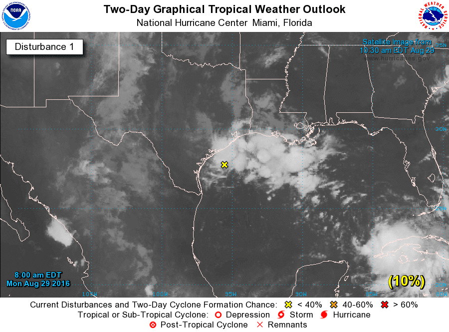
DISTURBANCE IN THE NORTHWEST GULF OF MEXICO


A weak area of low pressure near the Texas coast will wander southwestward, but it should not develop. Heavy rain will be the main threat in southeastern Texas. The latest outlook from the National Hurricane Center says:
A weak trough of low pressure located just offshore of the central
coast of Texas is producing disorganized showers and a few
thunderstorms over the northwestern Gulf of Mexico and adjacent
coastal areas.  Proximity to land and only marginally favorable
upper-level winds are expected to inhibit development while the
system drifts southwestward during the next day or so.  For
additional information on the rainfall associated with this system,
please see products from your local National Weather Service office.
* Formation chance through 48 hours...low...10 percent
* Formation chance through 5 days...low...10 percent


HURRICANE GASTON


At 4 PM CDT Sunday, Gaston became the first major hurricane (Category 3 or higher) of the 2016 Atlantic Hurricane Season. It has weakened a bit since then. Here's the latest from the National Hurricane Center:


SUMMARY OF 500 PM AST...2100 UTC...INFORMATION
----------------------------------------------
LOCATION...31.2N 55.2W
ABOUT 570 MI...915 KM E OF BERMUDA
ABOUT 1665 MI...2675 KM W OF THE AZORES
MAXIMUM SUSTAINED WINDS...105 MPH...165 KM/H
PRESENT MOVEMENT...NNE OR 30 DEGREES AT 3 MPH...6 KM/H
MINIMUM CENTRAL PRESSURE...968 MB...28.59 INCHES
Gaston is a strong Category 2 hurricane, and it's expected to slowly weaken back to tropical storm status as it approaches the Azores this weekend.


Models are in pretty good agreement through the next several days as Gaston makes that turn toward the northeast. The only threat to land could be the Azores late next week, but a lot can change between now and then.

TROPICAL DEPRESSION EIGHT


Well, Tropical Depression Eight is encountering some strong shear, leaving the system lopsided. The shear is going to help keep TD 8 in check. Right now, here is the latest from the National Hurricane Center:

SUMMARY OF 500 PM EDT...2100 UTC...INFORMATION
----------------------------------------------
LOCATION...33.6N 74.0W
ABOUT 140 MI...225 KM SE OF CAPE HATTERAS NORTH CAROLINA
MAXIMUM SUSTAINED WINDS...35 MPH...55 KM/H
PRESENT MOVEMENT...NW OR 310 DEGREES AT 6 MPH...9 KM/H
MINIMUM CENTRAL PRESSURE...1011 MB...29.86 INCHES
Tropical Storm Warnings are in effect for the Outer Banks of North Carolina from Cape Lookout to Oregon Inlet and also for Pamlico Sound. A Tropical Storm Warning means that that tropical storm conditions (sustained winds of 39 mph or greater) are expected within the next 36 hours. However, even if TD 8 doesn't make landfall, most of the showers and storms will be on the west side of the system. Also, it appears that TD 8 will not become a particularly strong tropical storm. But, heavy rain, rough surf, and deadly rip currents will be possible for portions of coastal North Carolina.


Anything after 72 hours is the result of TD 8 losing its identity and merging with a front. But, models are in decent agreement about bringing TD 8 close to the North Carolina coast before being swept out into the far north Atlantic.

TROPICAL DEPRESSION NINE


After about 11 days of tracking this system as Invest 99L, it finally became a tropical depression Sunday afternoon after the Hurricane Hunters found that former-99L had a well-defined closed circulation. Now, that does not mean it's well-organized. It has been battling wind shear, but that is starting to subside as TD 9 moves into the Gulf of Mexico. Right now, the main thing that TD 9 is battling is some dry air. Here's the latest from the National Hurricane Center:


SUMMARY OF 500 PM EDT...2100 UTC...INFORMATION
----------------------------------------------
LOCATION...24.0N 84.8W
ABOUT 195 MI...310 KM WSW OF KEY WEST FLORIDA
ABOUT 160 MI...260 KM WNW OF HAVANA CUBA
MAXIMUM SUSTAINED WINDS...35 MPH...55 KM/H
PRESENT MOVEMENT...WNW OR 290 DEGREES AT 5 MPH...7 KM/H
MINIMUM CENTRAL PRESSURE...1007 MB...29.74 INCHES
The National Hurricane Center notes that a Tropical Storm or Hurricane Watch may be required for a portion of the Florida Gulf Coast. Now, TD 9 actually took a dive to the west-southwest Sunday evening as it was interacting with Cuba. Most of the time, land is not a good thing for tropical cyclones. But sometimes, it can help the circulation a bit. With the friction caused by land, TD 9's circulation was able to tighten up on the southern side and convection to flare up on the southern side of its circulation. This allowed for TD 9 to move a bit more to the west-southwest. But, it has since started moving toward the west. Eventually, TD 9 is expected to turn more toward the northwest and then to the north. Then, a cold front (the same one expected to sweep away TD 8) will cause TD 9 to turn toward the northeast. Where and when all these turns occur will ultimately determine where TD 9 will make landfall. The current forecast from the National Hurrican Center calls for a strong tropical storm to make landfall somewhere between Port St. Joe and Sarasota.


These are the possibilities of seeing tropical storm force winds (sustained winds greater than or equal to 39 mph). Right now, the best chance looks to be between Port St. Joe and Tampa. Again, a lot can change between now and Thursday (when this could make landfall).

Let's look at the models and see what they're saying:


The one thing that models agree on is that TD 9 will eventually turn toward the northeast, but they greatly differ on when that turn will occur, so the models are really spread from Pensacola to Fort Myers. Again, still need to watch this system anywhere in Florida.

Let's look at our two most reliable models (GFS and ECMWF):


This is the 12Z (7 AM CDT) run of the GFS from Monday morning. This run is generally in the middle of all the guidance, but may have trended a touch north with a landfall southwest of Perry as a tropical storm. Again, this is just one run of one model. But let's look at the ECMWF.


The ECMWF is stronger than the GFS, but essentially the same track. However, the ECMWF, like the GFS, also has trended just slightly more west and north compared to the last run. And this slight shift westward can be seen in our model ensembles.


Ensembles (in this case, the GEFS) are the same model (in this case, the GFS) run with slightly different initial conditions. These alterations in the initial conditions help provide a range of possibilities. On the map above, all of the tiny red numbers near the Florida Panjandle are different positions for TD 9. There is a bit more cluster near Panama City and Apalachicola. This is just something to monitor as we go forward in time.

Note that even a strong tropical storm can cause storm surge issues in the Big Bend of Florida. That area is one of the most storm surge prone areas in the United States. The storm is likely to be lopsided due to some shear, so most of the impacts will be felt on the eastern and southeastern side of the system. Heavy rain, gusty winds, dangerous surf, elevated tides, some storm surge, and deadly rip currents are all possible threats which will be fine tuned as we move forward.

TROPICAL WAVE COMING OFF OF AFRICA


There is a pretty strong tropical wave coming off the coast of Africa into the tropical Atlantic and moving near the Cabo Verde Islands. This is the latest from the National Hurricane Center:
A tropical wave is expected to move offshore of the west coast of
Africa tonight.  Conditions are expected to be favorable for gradual
development of this system later this week while it moves westward
at 15 to 20 mph over the tropical Atlantic.
* Formation chance through 48 hours...low...near 0 percent
* Formation chance through 5 days...medium...50 percent


The above animations are the GFS (top) and ECMWF (bottom) out to 7 AM CDT September 3rd. Both models generally agree that this wave (probably will be designated Invest 92L) will move westward across the tropical Atlantic. However, it is way too far out to speculate what will happen beyond 5 days.


Now, remember to get all your information from official sources (NOAA, NWS, NHC, etc.). You can find detailed information about watches and warnings from your local National Weather Service office here. The latest tropical cyclone information (and where I got several of the graphics in this blog) can be found here. Follow the direction of your local officials and emergency management for preparation tips and evacuation information (if it becomes necessary). Make sure your emergency preparedness kit is stocked at all times.

Also, credits to Levi Cowan's website for the model graphics.