Showing posts with label 99L. Show all posts

Saturday, August 27, 2016

An Active Atlantic, Typical for Late August

So, if you're not quite fatigued from hearing about Invest 99L yet, then you may be after you see all the systems we are watching now. First, we will start with a system that is already named... Gaston.

TROPICAL STORM GASTON


Gaston has been fighting off some wind shear over the past couple of days, it is starting to re-strengthen yet again. Thankfully, Gaston is expected to remain over the open waters of the Atlantic and not impact any land areas directly over the next 5 days.


As you can see, Gaston will not be making landfall anywhere through at least the next 5 days, but it will become a hurricane yet again as it moves over the open Atlantic.

DISTURBANCE IN THE NORTHWEST GULF OF MEXICO


The disturbance being monitored here is just off the coast of Texas and Louisiana. This trough of low pressure has a near zero chance of development as it moves onshore Sunday. This is the latest from the National Hurricane Center:
A weak trough of low pressure located south of the coast of
southwestern Louisiana is producing disorganized shower and
thunderstorm activity over the north-central Gulf of Mexico.
Conditions are not expected to be conducive for development before
this system reaches the coast of Texas on Sunday.  However, heavy
rainfall is possible along the Gulf Coast from Louisiana to
southeastern Texas during the next few days.  For additional
information, please see products from your local National Weather
Service office.
* Formation chance through 48 hours...low...near 0 percent
* Formation chance through 5 days...low...near 0 percent
While it isn't expected to develop, we are looking at more unwanted rain for southern Louisiana and southeastern Texas.

INVEST 91L


Yes, we do have another area of investigation from the National Hurricane Center. This is 91L located to the southwest of Berumda. It has a pretty vigorous low level circulation, but the convection is being sheared.


The latest from the National Hurricane Center says:
A broad area of low pressure located about 140 miles southwest of
Bermuda is producing winds of 30 to 35 mph.  Shower and thunderstorm
activity has not become any better organized during the past few
hours, and significant development of this system is likely to be
slow to occur due the proximity of dry air during the next couple of
days while it moves westward and then west-northwestward at about
10 mph toward the coast of North Carolina.  After that time,
increasing vertical wind shear is expected to make development
unlikely.  For additional information on this system, see High Seas
Forecasts issued by the National Weather Service.
* Formation chance through 48 hours...low...30 percent
* Formation chance through 5 days...low...30 percent

Models generally agree on taking 91L west-northwestward toward the North Carolina coast and Outer Banks before slinging it back out into the Atlantic. If 91L develops, it probably won't be anything too strong, but it will likely bring some heavy rainfall to parts of North Carolina.

INVEST 99L


Yes, we are still talking about this thing. Bless its heart. It really is trying. It actually looks better than it has in recent days, but looks can be a bit deceiving. Some observations from earlier suggest that a low-level circulation was trying to form, but it was displaced from the mid-level center, shearing some of the convection. Also, now we have thunderstorms firing over Cuba, part of the daytime hearing, which is taking away energy from 99L. So, development chances, for right now, don't look all that great. The latest from the National Hurricane Center says:


A weak area of low pressure located between the northern coast of
Cuba and Andros Island in the Bahamas continues to produce a large
area of disorganized showers and thunderstorms, mainly to the south
and east of its center.  Upper-level winds are not conducive for
significant development during the next day or so while the low
moves west-northwestward through the Straits of Florida at about 10
mph.  Environmental conditions could become a little more conducive
for some development when the system moves into the eastern Gulf of
Mexico early next week.  Heavy rains are likely to continue over
portions of eastern and central Cuba today.  Gusty winds and locally
heavy rainfall are likely over portions of the Bahamas, and will
spread into parts of southern Florida and the Florida Keys by
Sunday.  Interests elsewhere in Florida and the eastern Gulf of
Mexico should continue to monitor the progress of this disturbance.
The Hurricane Hunter aircraft mission scheduled to investigate this
system today has been canceled.
* Formation chance through 48 hours...low...30 percent
* Formation chance through 5 days...medium...40 percent
So, while development chances are lower than they have been, they still are not zero. You can never say never when it comes to the tropics in late August. Now, it looks a little better, but does that mean we have a little better handle on where it's going?


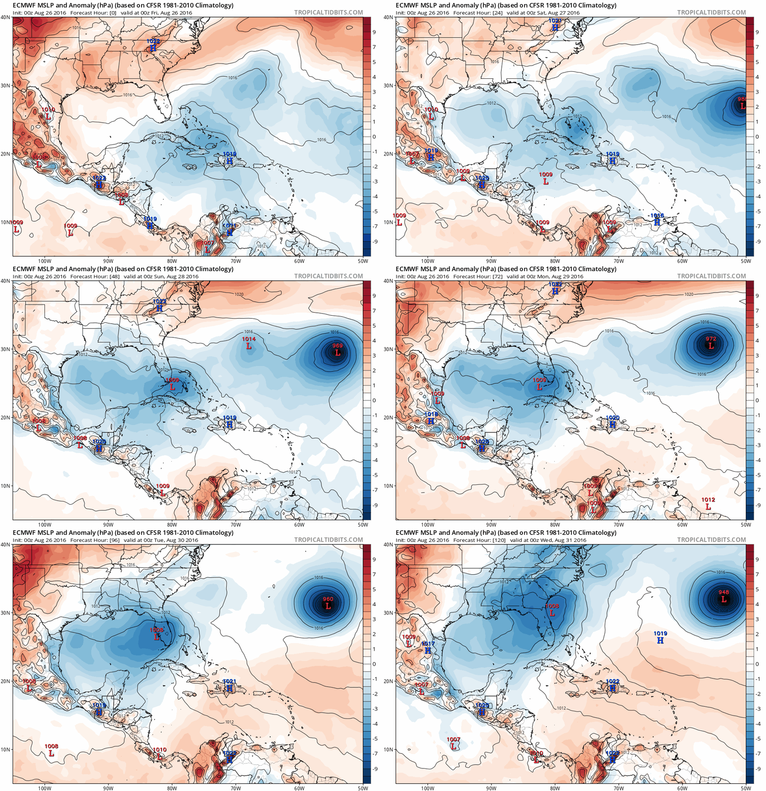
For the first 48 hours, somewhat yes. After that, still no idea. We are pretty confident that 99L will pass through the Florida Straits into the southeastern Gulf of Mexico. After that, as has been the case for the last several days, the models wildly diverge in both track and intensity. Now, the one thing the models do agree on is that there will be a more favorable environment for some sort of possible development. So, it is possible for 99L to get into the Gulf and try to organize itself. But, once again, we are still talking about a system that is not organized. So, really, the models cannot be fully trusted beyond 48 hours, giving us a rather low confidence in any sort of forecast. Our two most reliable models (GFS and ECMWF) have been at odds with each other for a while now. Let's take a look at their 00Z runs from last night.


So, on top we have the 00Z GFS running out through 7 PM Sept. 1, and below it we have the 00Z ECMWF running out through the same time. Now, neither the GFS or the ECMWF really develop 99L. The GFS actually splits 99L with part of the energy left drifting west in the Gulf of Mexico and another part developing off the northeast coast of Florida.

The ECMWF doesn't really develop it either. It kind of makes 99L an elongated system that extends from the central Gulf into the southeast. Somewhat similar, a d both showing weak solutions. So, small victories for some agreement, right? Now, let's see if the models changed 12 hours later.


So, these are the 12Z runs of the GFS (top) and the the ECMWF (bottom). No the go out to 7 AM Sept. 1. Let's look at the GFS first. The GFS is a little stronger with this run than its 00Z run. It takes 99L up the west coast of Florida, then sort of merges it with 91L before sending it out to sea.

The ECMWF is a completely different story. It shows 99L a good bit stronger than the GFS's runs and its own 00Z run. It takes 99L west into the central Gulf and kind of stalls it. There are reasons I'm not showing beyond this time frame:
  1. It's beyond 5 days out.
  2. The end of the 12Z run of the ECMWF probably should not be seen.
But, the GFS has one thing going for it. It has decent run-to-run consistency. I won't say it's good, but it's okay. It continues to show something weak that (at least in part) affects the west coast of Florida. The ECMWF does not have good run-to-run consistency. It keeps jumping from weak to strong and shifting the track back and forth.

However, the models can and will change, as we've seen over the past several days. I think once it gets into the Gulf, we will have a better idea of what it will do.

TROPICAL WAVE COMING OFF OF AFRICA NEXT WEEK

Nope, we aren't through yet. We now turn our attention to western Africa for the next potential tropical system.


So, I know I told you I didn't want to show you anything past Day 5 on models, but I'm going to break that rule here. There has been some good agreement on a tropical wave emerging from Africa on Tuesday. Above are the 12Z GFS (top) and ECMWF (bottom) out to 7 AM Sept. 6. Now, the models have consistently shown this and are in pretty good agreement out to Day 8 or so, which is pretty rare. But, if this wave holds together, there are pretty good indications that it could develop into the next named storm (Hermine, Ian, or Julia, depending on if 99L and/or 91L get named). This is still about 3 to 5 days out,  it this is what the National Hurricane Center is saying:
A tropical wave is expected to move offshore of the west coast of
Africa on Tuesday.  Conditions appear favorable for development of
this system later next week while it moves westward at 15 to 20 mph.
* Formation chance through 48 hours...low...near 0 percent
* Formation chance through 5 days...low...30 percent
So, again, with all this said, just stay up-to-date with your official sources. Anything can change, but just stay aware and stay prepared as we are now (basically) in the peak of hurricane season.


Again, credits go to Levi Cowan and his website, Tropical Tidbits, for all the forecast images. 

Friday, August 26, 2016

Tropical Headaches: Invest 99L Edition


This gif perfectly describes the mood of all meteorologists (including myself) who have been watching 99L and the forecast models. Forecasting is a very difficult skill, and usually models make it a little easier on us. Well, that is unless your two most reliable models differ highly in their solutions, change from run to run drastically, and your system that you're monitoring refuses to develop. So, let's try to make sense of everything here.

WARNING FOR NON-METEOROLOGISTS: There will be quite a bit of meteorology in this post, but I will do my best to explain everything as I go.

DISCLAIMER: All models shown are to be used only as guidance. Please do not take any one run of any model and use that as your forecast. They are not exact truth. They will change.

So, let's get to 99L. (Don't worry. Gaston is still out there, but it doesn't have an affect on us.)


So, pop quiz: Where is the center? Answer: there isn't one, or, really, not one that is defined. There was a small circulation that we have been monitoring, and, it's really hard to see it on here, but it may be just north of the eastern tip of Cuba. But, all of this is to say that 99L is extremely disorganized.


Because of this disorganization, the National Hurricane Center decreased the chances of development to 30% next 2 days and 60% next 5 days. Note, however, that the area for development does now stretch into the southern Gulf of Mexico. Anytime a system works its way into the Gulf, it definitely bears watching.

But what are the conditions ahead of 99L? Good question. We are going to look at 3 things before we talk about the forecast: wind shear, water temperatures, and moisture. First, wind shear.


Wind shear is simply defined as the change of the wind (both speed and direction) with height. Wind shear is helpful for severe weather, but not so much for tropical cyclone formation. Above is a map of the wind shear as of 03Z (10 PM CDT). Note that 99L is now north of the eastern tip of Cuba. It's in a zone of pretty high wind shear (20-30 knots of shear). This is why 99L has pretty much been naked all day. But, 99L is forecast to move between Florida and Cuba, where there is much less shear forecast. This could aid in development. But there are still other factors to consider. Next up, water temperatures.


Above are the sea surface temperature maps for the Caribbean and the Gulf of Mexico. As a general rule of thumb, we typically say that 80°F. (26.7°C) is a good threshold for sustaining or helpful for development of tropical cyclones. On these maps, that is basically anything that is yellow, orange, or red. Absolutely not a problem here. But surface temperature isn't the only thing to focus on, but how deep is that warm water?


These maps show the "depth of the 26°C isotherm." Basically, this shows how deep the water temperature of 79°F. is. The deeper the warm water is, the more energy a tropical cyclone has to thrive on. Between Florida and Cuba, there is a good amount of depth to the warm water. In the Gulf of Mexico, not so much. As a tropical system (or really, any rain for that matter) passes over the water, it cools the surface layer of the water. If you remember back from high school science classes: warm air rises, cold air sinks. Well, the same works with water. As the water cools, it will sink and be replaced by the water underneath it. If the water below is still warm, then it can help support a tropical cyclone. But if the water temperature is too cool, then it may actually help to weaken the system. We see this a lot with tropical cyclones that stall. They will sit over the same part of the water and keep cooling the surface water. Eventually, it runs out of warm water to bring back up to the surface, and the column of water underneath just gets completely cooled. And we need warm warm water to sustain tropical cyclones. Now, one last thing: moisture.


Now, if you're not a meteorologist, you're probably looking at this wondering what in the world it is. This is a skew-T log-p diagram. I won't go into too much detail about what it shows, but heres a quick rundown. The numbers on the left are pressure in millibars (mb). Note that as you go up on the chart (in the atmosphere) the pressure decreases (logarithmically). The numbers on the bottom are temperature in °C. There are thin blue lines that go diagonally up and to the right that represent the temperature every 5 degrees (skewed temperature lines). The seemingly-random lines on the right are the wind speed and direction, but we aren't worth about those. These graphs essentially show a trace of temperature and dew point through the atmosphere. The temperature trace is the right bold line and the dew point is the left bold line. The closer they are, the more moisture there is in that part of the atmosphere, and the farther apart they are, the drier it is. So, these are two diagrams ("soundings") from nearby locations: Santo Domingo, Dominican Republic; and Nassau, Bahamas. Note on the sounding from Nassau that it is pretty dry from about 800 mb and up. Also note on Santo Domingo's sounding the dry layer from about 800 to 650 mb. Tropical cyclones need moisture to help get clouds, showers, and thunderstorms. In this case, we really don't have much of it, which is part of the reason 99L has been struggling.

Okay, now that we got through all of that, let's look at some forecasts.


These are the spaghetti plots for 99L. And, it quite literally looks like a child threw his/her spaghetti all over the map. Each line represents a different model projecting the path of 99L. (If you want to know a bit more about these models, the University of Wisconsin-Milwaukee has an excellent site here.) Right now, the models are quite uncerain about what will happen, though I can summarize their thinking right here: (in general) the models that are taking it further west show a weaker system; the models taking it further north show a slightly stronger system. Now, I've talked about the great debate between the GFS and the ECMWF. Well, things got a bit more interesting (and frustrating) Thursday. Lets start from the 00Z (7 PM CDT) runs of the GFS and the ECMWF from Wednesday night.


Pictured above are the GFS (top) and ECMWF (bottom) runs from Wednesday night going from 7 PM Thursday through 7 PM next Wednesday. You can see that the GFS and ECMWF have similar tracks, but the GFS is considerably weaker than the ECMWF. In fact, the GFS never really developed it, whereas the ECMWF had a landfalling hurricane in the Big Bend. Now, let's take the run 12 hours later from these models.


So this is the 12Z (7 AM CDT) run of the GFS (top) and ECMWF (bottom) for the same timeframe as above (ECMWF is 12 hours later than the GFS since it only goes by 24 hour increments). The GFS brings something west into the Gulf of Mexico, but dissipates it. The ECMWF still shows landfall in the Big Bend, but it's considerably weaker. Still more questions than answers at this time. But, NOAA sent out a couple missions to sample the environment around the system so that we could get a better handle on the conditions 99L could move into. So, let's look at the most recent run of the GFS and ECMWF with that new data put in.


These are the most current runs (as of this posting) of the GFS (top) and ECMWF (bottom) for the same timeframe as above. Curiously, the GFS is a bit stronger than previous runs and brings it north toward the Gulf Coast. Actually, most of the 0Z guidance was stronger, except for one... The ECMWF. The ECMWF has the storm very weak hitting the west coast of Florida.

So, which one do we trust? Again, we don't know. Right now, it's a wait and see situation. But, no matter what, you should be prepared for anything with your emergency supply kit. Just make sure you keep up with it. Again, no reason to panic, no reason to worry right now. Just keep an eye on this system.


Again, most of the graphics came from Levi Cowan's site. You can check it out here.

Wednesday, August 24, 2016

Watching the Tropics: Gaston and 99L

If you've been watching the news or browsing social media, you've probably heard about the active tropics. We have two systems in the Atlantic. One is named, and the other is not (yet). Let's talk about Tropical Storm Gaston first.

TROPICAL STORM GASTON


This is a satellite view of Tropical Storm Gaston as of 3:45 PM CDT. It is a pretty well-organized system. Here is the information from the National Hurricane Center as of 4 PM CDT:

Location: 17.4 N, 40.6 W; about 1,100 miles west of the Cabo Verde Islands
Movement: NW at 16 mph
Winds: 70 mph
Pressure: 990 mb


This is the projected path from the National Hurricane Center for Gaston. It is forecast to weaken Thursday. This is because Gaston will encounter some strong wind shear. However, by Saturday, it looks like Gaston will restrengthen back to hurricane status. All in all, Gaston does not appear to affect any land areas for the next several days.

INVEST 99L

Before I begin: This is NOT a developed system. Since it is disorganized, there is a much higher degree of uncertainty. Take all models shown in this section as guidance. They are NOT truth. They WILL change. This all just provides a general idea of what could happen. Remember, my goal with this post is to inform and NOT to incite fear or panic. Keep all of this in mind while reading this section.


Now, this is likely the one you've been hearing about. Right now, it's rather disorganized, and conditions are only marginally favorable for it to develop right now.


As of 1 PM CDT, the National Hurricane Center gives 99L a 60% chance of becoming a tropical depression or a tropical storm over the next 2 days, but an 80% chance over the next 5 days. Conditions appear to be much more favorable as the system moves toward the Bahamas. The National Hurricane Center does note that: "this system could become a tropical storm or tropical depression at any time during the next couple of days."

Now, you can see that the red-hatched area is the area of expected motion and development. We are fairly confident that 99L will move west-northwestward toward the Bahamas and southern Florida. That's about 5 days out. And really, that's all we're somewhat confident about.


Let's look at the current stats on Invest 99L:
Location: 18.7 N, 65.4 W; generally north of the U.S. Virgin Islands and northeast of Puerto Rico
Winds: 45 mph
Pressure: 1009 mb


Now, these are the "spaghetti" plots for 99L as of 18Z (1 PM CDT). These are tracking where the center of the system will move. IMPORTANT: impacts can extend far beyond the center of the system. You can see that the majority of the models take the system toward the Bahamas in 5 days (120 hours). Then, the models try to take 99L (or what could be Hermine at this point in time) either into the eastern Gulf of Mexico or up the Florida Peninsula. There is still quite a spread at this point. Also...


There has been quite a bit of inconsistency with the models past the Bahamas. Anywhere from the central Gulf of Mexico to the spine of Florida has been the target of these models. I've also seen models taking it as far as Houston or missing Florida to the east.

Two of our most reliable models have been at odds with each other over the past several days: the GFS and the ECMWF. Let's start with a look at the GFS.


This is the 12Z (7 AM CDT) run of the GFS out 168 hours (1 week). Note that it really doesn't develop the system at all, and it moves it off the east coast of Florida. Now, there is a problem with this run: it's not all that reasonable.


Pictured above are the 500 mb and 850 mb (about 17,000 feet and 5,000 feet high, respectively) forecast maps in 4 days (96 hours). On both maps, the black "H" represents a high aloft. The bold arrows around the high are the steering flow around that high. Then, I have 99L marked where it would be according to the GFS with an arrow pointing up the east coast of Florida, showing the path the GFS is forecasting.

So, here is the problem. There is an upper level high to the north of 99L at this time forecast by the GFS. There is no weakness (no troughing) in the ridge to support this moving north, even if it is a shallow system (besides, stronger systems tend to feel weaknesses more than weaker systems). With the upper level high to the north, the steering flow should be driving 99L to the west, not the north. Thus, I am not considering the 12Z run of the GFS as a viable option.

Now, what about previous runs?


This animation shows the last 12 runs of the GFS all valid at 7 AM on Aug. 30 (next Tuesday). Note how the position of the low changes radically for all the previous forecasts: from the central Gulf, to the southern tip of Florida, to off the east coast of Florida. This tells me that the GFS is having issues with this system. Granted, it is a disorganized system right now.

But let's look at the other competing model: the ECMWF.


Now, this is typically the more reliable model, and in this case, it has the better idea: taking it across the southern tip of Florida due to the ridge to its north. But this one takes it along the west coast of Florida into the Big Bend. So, how has the ECMWF's consistency held up?


Better than the GFS, but still not where we'd like it. This is the last 6 runs of the ECMWF (this model only runs twice a day, the GFS runs 4 times a day) valid at 7 AM CDT Aug. 30 (next Tuesday). For all but one run, the ECMWF takes 99L into the Gulf of Mexico.

However, here's a major caveat: we still do not have a well defined center with 99L. Until we get that well-defined center, the models, no matter how good they are, will struggle to resolve it. Thus, the models will continue to spit out different solutions since it does not have a good starting point.

Now, let's answer a few questions that you probably have:

  1. Where is it going? Excellent question. In the short term, to the Bahamas. There is modest agreement that it will cross the southern part of Florida (ignoring the 12Z GFS). After that, we simply have no idea. Until this system gets better organized, we won't have a clear cut answer.
  2. How strong will it be? Another excellent question. Let's look at model guidance to see if it tells us anything.

    Hmmm, nope. Once again, we don't have a well-defined system. Add on top of that, intensity forecasting is a science that we have not fully grasped yet. So, to answer your question, we simply have no idea. It depends on when it develops, the forecast track (when it gets a well-defined center), and many, many other things. Chances are we will know more as time goes on.
  3. What should I do right now? Well, I have a two-part answer:

    If you live in the Bahamas or southern Florida: monitor this system closely. You are now within 5 days of potential impacts. It's probably a good idea to go ahead and restock your emergency preparedness kit. You don't want to be caught off guard if this system develops. Go over your disaster preparedness plan. Do you know your evacuation routes? Do you know where your shelters are? What will you do about your pets? (Remember, some shelters do not allow pets.) What evacuation zone do you live in? Really, all of these questions should have been answered at the beginning of hurricane season, but you definitely should review now.

    If you live elsewhere in Florida or along the northern Gulf Coast: keep an eye on this system. Right now, it is still about a week away from any impacts (if they are to occur). However, you should be checking your emergency preparedness kit as well. Ask yourself the same questions as above.

    Regardless, this is not the time to panic and worry. But, it is hurricane season, and you should always be prepared with your plan, just in case anything were to happen.
  4. So-and-so says that a hurricane is headed for my home. Should I believe them? Frankly, no. At least, not right now. Remember, this system doesn't even have a well-defined center, and it isn't even classified yet. Since it doesn't have a well-defined center, the models will struggle, and they will give you a different solution each time it runs. Make sure you always get your information from official sources (NWS, NOAA, NHC, etc.). If the official sources are saying something, you should believe them and heed their advice.
So, what's the takeaway from all of this?
  1. Gaston will not affect land, though it is likely to become a hurricane this weekend.
  2. 99L has a high chance of becoming our next named storm: Hermine (her-MEEN)
  3. 99L currently does not have a well-defined center, and until it does, it will not be classified as a tropical storm (even though it is producing tropical-storm-force winds).
  4. 99L will likely move toward the Bahamas and southern Florida, though intensity remains very uncertain.
  5. 99L may cross into the Gulf of Mexico. However, where it goes and how strong it will be is unknown.
  6. The models WILL change. That is something that we are certain about.
  7. If anyone, at this point, tries to give you an exact forecast, do not believe them!
  8. Stay alert of the tropics, but do not panic or worry.
  9. You should always be prepared just in case. It's never a bad idea to be over-prepared.
  10. Know your sources!
  11. Again, don't worry! Just be prepared. Have a plan, and be ready to put the plan into action if necessary.

Once again, all forecast model images come from Levi Cowan's amazing website. Check it out here.

Also, find the latest official informarion from the National Hurricane Center here.

Tuesday, August 23, 2016

Fiona Fades, Gaston Grows, 99L Needs Watching

A Very Active Atlantic


Well, it's late August, and we are fast approaching the climatological peak of the Atlantic Hurricane Season. As you might expect, the tropics are pretty active. We have one active named storm, one that was declared post-tropical, and another that has a high chance of becoming a tropical cyclone.

Post-Tropical Cyclone Fiona


Not, not that Fiona.


THIS is The Fiona we're talking about. The National Hurricane Center (NHC) has issued its last advisory on Fiona as of 10 AM CDT. The satellite loop is as of 9:45 PM this evening, and there really isn't much left of it.

Tropical Storm Gaston


Again, no, not this Gaston.


We are talking about THIS Gaston. As of 10 PM CDT, here were the specs for Tropical Storm Gaston:

Location: 14.7°N., 37.1°W., or about 875 miles west of the southernmost Cabo Verde Islands
Moving WNW at 17 mph
Maximum sustained winds: 65 mph
Minimum central pressure: 1002 mb


Thaankfully, the NHC's projected path takes it away from any land, and well to the east of Bermuda. Gaston is forecast to become a hurricane but will remain over open waters


Model guidance agrees that Gaston will become a hurricane, and most do bring it up to Category 2 Intensity. There are a few that do bring it up to a Category 3, which would make it a major hurricane. We will see what happens with Gaston over the next few days, but it remains an interest only for the ships and fish.

INVEST 99L


Now, this is the one that will have impacts to land. Right now, it's rather disorganized.


The NHC has indicated that there is a broad area of low pressure associated with these showers and thunderstorms. It will move west-northwestward during the coming days toward the Leeward Islands, the U.S. Virgin Islands, Puerto Rico, Hispaniola, and the Bahamas. Environmental conditions are only marginally favorable for development, but they will be better once the system reaches the Bahamas. The NHC gives 99L a 50% chance of formation during the next 2 days, and a 70% chance during the next 5 days.

Now, let's look at some model guidance. And that's all it should be taken as: guidance. This is not gospel truth. This can and will change easily, especially with an ill-defined system.


The models are in decent agreement that 99L will move toward the west-northwest eventually impacting the Bahamas in about 5 days, just as the NHC had shown. Now, after 5 days, most of the models agree on 99L crossing over south Florida into the southern Gulf of Mexico. Where it goes from there is anyone's guess. In fact, two of the most reliable models show very different solutions: GFS and ECMWF.


This is the 00Z (7 PM CDT) run of the GFS model valid for 7 PM next Tuesday. The GFS shows what appears to be a weak tropical depression over the Florida Peninsula, very near Orlando. You can also see what would be a large Hurricane Gaston well to the east of Bermuda. But again, this is just one run of one model. Now, let's look at the ECMWF.


Okay, so now, this is a bit different, and by a bit, I mean a lot. This is the 12Z (7 AM CDT) ECMWF run valid for 7 AM Tuesday. (The ECMWF runs only twice a day, whereas the GFS runs 4 times a day, hence the different runs pictures here.) The first notable difference is its intensity. The GFS had a weak tropical depression; the ECMWF has a major hurricane. The other notable difference is its location. The GFS had it over central Florida; the ECMWF has it south of northwest Florida. But also note what it does with Gaston. It makes it a much more intense, yet more compact, hurricane than the GFS. But this, yet again, is just one run of one model.


And, if you thought that the discrepancy was bad between the GFS and the ECMWF, look at the uncertainty in intensity forecasts. Literally, from nothing up to a Category 4 Hurricane. Intensity forecasting, in general, still has a long way to go. Frankly, we aren't that good at forecasting intensity, especially with all of the factors that go into it. Really, we just won't have a good idea until this gets a well-defined center and gets away from the Caribbean islands, and even then, there likely will still be a good degree of uncertainty.

So, what is the takeaway from all of this? We have two very reliable models that show two very different solutions for the same system. The first takeaway is that the models at least agree on bringing the system toward the Bahamas and southern Florida in about 5 days. The models also somewhat agree that the system will eventually end up in the Gulf of Mexico. Those really are our only takeaways that we have. Intensity-wise, we don't have a clue. Where it will end up making a final landfall, we don't know that either.

Now, before you think that this is all, let me throw 2 more wrenches into this mess.

What about possible center reformations? This happens especially with disorganized or sheared systems, like 99L is right now. It keeps spitting out little low level vortices that eventually decay and form with a new convective flare up. These center reformations are not predicted very well by the models, and they could have a pretty substantial impact on where it eventually goes and what/how steering mechanisms impact it.

What about Hispaniola? Hispaniola is home to the highest mountains in the Caribbean (around 10,000 feet). Tropical cyclones hate mountains. The mountains can completely shred a circulation to pieces. If 99L were to have its center form a bit to the south, the future track could also shift south and bring it over Hispaniola, which could destroy 99L.

Now, if there is one thing I want you to take away from this post, it's this: Regardless of what this becomes and where it goes, you should be prepared. It can't hurt to prepare for this system. If it hits you, you're prepared. If it misses you, great, you're prepared for the next one.
  • Make sure your readiness kit is stocked: flashlights, batteries, radios, 3 days supply of food and water per person, first aid kit, etc.
  • Know your evacuation zones, and know your evacuation routes.
  • Make sure you have a plan for your pets should you need to evacuate. Remember that some shelters do not take pets.
  • Know where your shelters are located.
Really, you should be prepared for a disaster at all times, but especially during the peak of hurricane sseason.

So, in summary (tl;dr):
  1. Fiona has fizzled.
  2. Gaston will become a hurricane but will have no impact to land.
  3. 99L has a good chance of developing.
  4. 99L will likely move toward the Bahamas and southern Florida this weekend.
  5. 99L could move into the Gulf of Mexico early next week.
  6. We do not know where it will go once it reaches the Gulf of Mexico as there is much disagreement among the models.
  7. We do not know how strong the system will be, period.
  8. We do not know how much of a role center reformations and/or Hispaniola will play into 99L's future.
  9. The models WILL change.
  10. No matter what, you should always be prepared.
  11. Avoid the hype. If anyone tells you that this is THE forecast for 99L, do not believe them, especially while this still isn't even a tropical depression yet.
Don't worry, stay safe, stay informed, be prepared, and know your sources.

By the way, the next name on the list is Hermine (her-MEEN), not Hermione. Sorry.


Most of the forecast graphics came from Levi Cowan's amazing website. Check it out here.